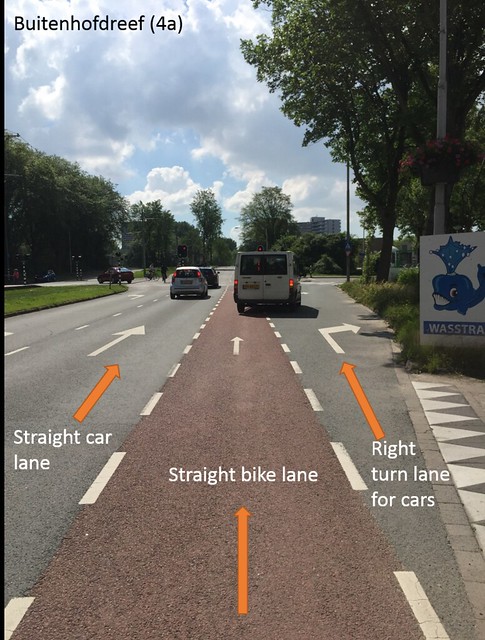
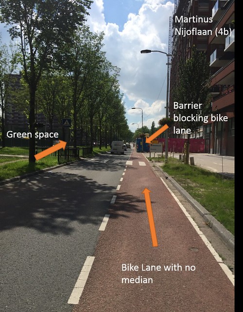
Bike Lanes (1, 2, 4)
Bike lanes are those where bikes have their own lane but there is no median between the cars and the bikes. There are only painted lines on the ground. These seem to be the less safe of the different facility types since there is nothing to protect the bikers from the cars. As shown in the picture depicting street segment 4a, there are some intersections where the right turn car lane crosses the bike lane. These can sometimes be pretty unsafe if the drivers turning don’t look around them for bikes before getting into the lane. Biking down the road I saw a truck turn into the lane while our group was going straight even though we had the right of way. In 4b there is a barrier blocking part of the bike lane for construction. I was stressed that I was close to the cars driving past me, didn’t feel as safe, and I just wanted to get off the road. In addition to being less safe, I also felt stressed while biking on the lanes and those biking around us seemed to be going faster. Regardless of the lane and without a median it makes bikers stressed about the cars around them. There is space for bikes, cars, pedestrians, and green space. The bike lane seemed to be normal size but the car lane was smaller than normal. There was a good amount of green space with trees and grass between the car lanes. There are sidewalks on the side of the road that are big enough for pedestrians. The bike lane facility is an inexpensive option compared to others and has all of the functions it needs. It has space for everyone, but it still felt slightly unsafe.
Bike Boulevard (3, 7)
Bike boulevards are small, local streets. These streets are very safe for bikers. In street segment 7, it was a small street where cars were only allowed in one direction and bikes could go both directions. That way, bikes wouldn’t have to worry about two lanes of cars and could feel safer riding down the road. When I was riding down the road I felt safe and calm. This street seemed very filled with leisurely riders including everyone from the young to elderly people. There weren’t too many cars driving down considering the safety measures that were implemented for the one way cars. The roads were rough and there were speed bumps so that the cars needed to go slow. There was parking on one side of the street and no bike lanes so that the bikers could bike wherever they wanted unless there were cars. This street was a historic street so the space is limited to between the canal and the houses. They couldn’t increase the area for the cars or bikes or pedestrians, so they had to make do with the space that was given to them. The pedestrians have enough room to walk down the street in their own area on the curb. The bikers have space to bike along with the one direction cars. It does seem that it didn’t cost too much to make the road since there aren’t any specific lanes and it was made a long time ago and hasn’t been changed; however, it feels safe and serves the purpose it was made to do.

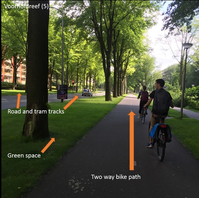
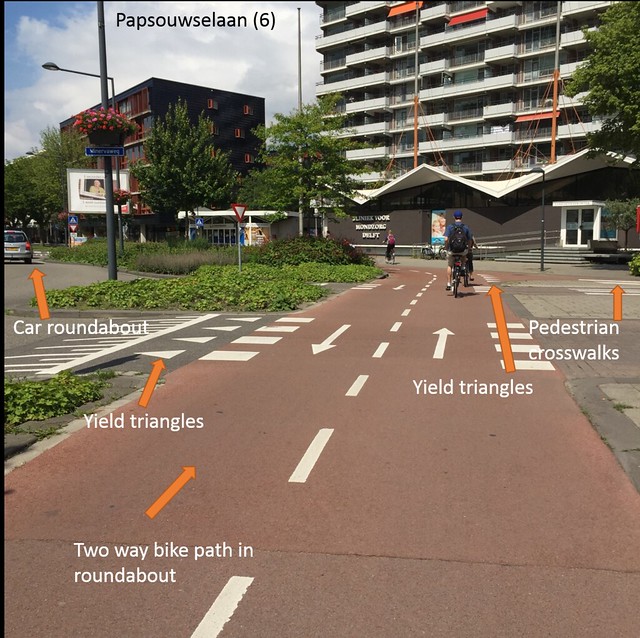
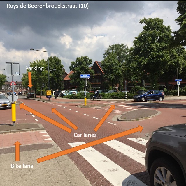
Cycle Tracks (5, 6, 10)
Cycle tracks are bike lanes that are separated from the car lanes with a median. These tracks feel safe because they are away from the cars and have a barrier to protect the bikers. Many of these medians are grass, trees, or bushes (green space) like in segment 5 and 6, or are parked cars like in segment 10. Riding down these areas, I felt calm and safe and didn’t need to rush. Everyone else that was riding down the road seemed to feel the same way, which I could tell by the way they were riding. The roundabout on segment 6 was a safe one. There were many measures that helped make it feel safe. Pedestrians had the outside lane of the roundabout and had crosswalks where they went over the car lanes and bike lanes. The pedestrians had the right of way over bikes and cars. The bikes then had priority over cars but had to yield when people were in the crosswalk and had yield triangles when getting out of the roundabout. Cars had to stop for everyone and it was clear when they had to yield with the yield triangles and the speed hump when getting off. I wasn’t sure about the tram though. I thought the bike lane might have lights for them to stop for the tram but I didn’t exactly know if that was for the tram or something else. Street segment 10 is one of the newer roads we saw. This road and especially the intersection with another road was one road that benefited from good planning. This road included many great aspects. It had two car lanes, a median of parking and bus areas, bike lanes on either side, and a wide pedestrian path. Although the intersection was confusing at first, there were enough signs and yields to prevent crashes. This road was expensive to create, but the intersection runs smoothly and every area (bikes, cars, and pedestrians) has their own wide space.
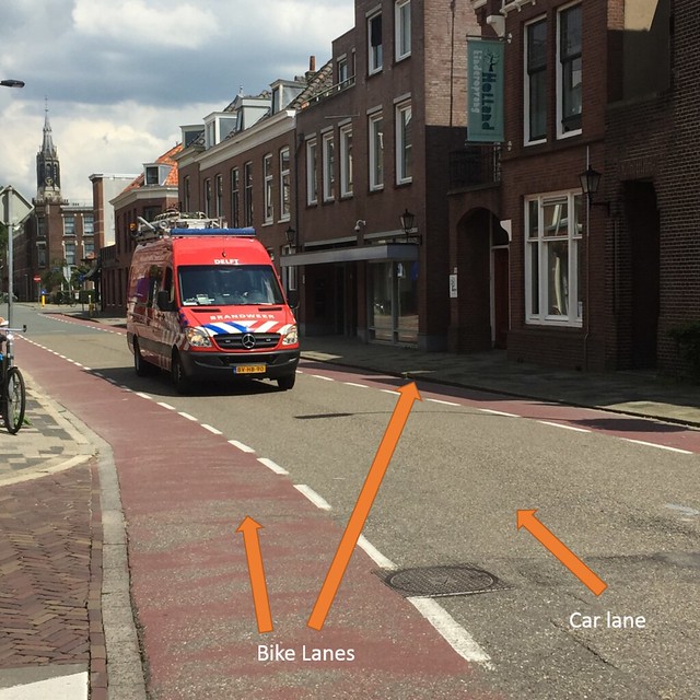
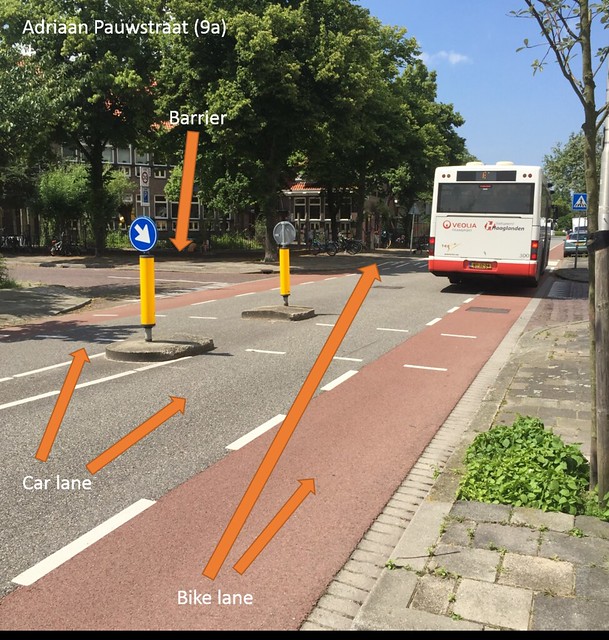
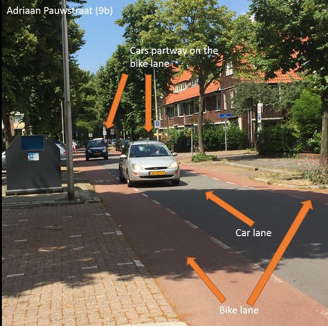
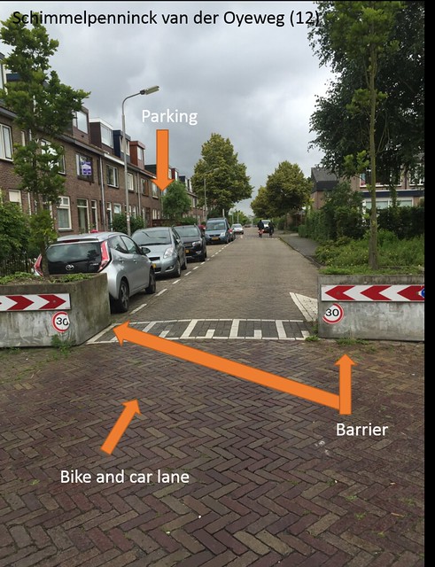
Advisory Lanes (8, 9, 11, 12)
Advisory lanes are those with bike lanes on either side and one lane for two-way traffic down the middle. The bikes in this situation are priority so cars have to wait until it is free to move around them. This facility type seems to be mostly safe since bikes have the priority although there is no median to protect them if something happens. Even though the bike lanes are suggestion lanes, the knowledge of drivers in the Netherlands and knowing that bike lanes are red, drivers stay out of the lanes unless they have to go in them. While I was on the road, there were not too many times where there were two cars going in different directions at the same time. As shown in the picture of street segment 8, the van takes up most of the lane by itself so if there was another car going the other direction, they would have to go into the bike lane. Besides vans, most of the time when there were two cars, both cars were barely in the bike lanes. In order to make the cars drive slow, seen in picture of segment 9, there are speed bumps and there is a barrier so the cars have to split and go into the bike lane. The drivers need to make sure that the bike lane is free before they go into it. Also, in segment 12, there were barriers to slow down the cars and the roads were rough. In order to have both bike lanes on these roads, there needed to be a tradeoff with the cars to make it safe for bikers to use. The cars don’t have enough room to drive side by side; however, it was needed in order to give priority to the bikers. The costs for this road don’t seem that expensive since it is just paint on the ground for the bike lanes. Regardless, the bikers are safe and cars can still move and travel easily. The roundabout between 9a and 9b was a little confusing about where the bikes yield because there is no light for bikes but the path crosses the street.
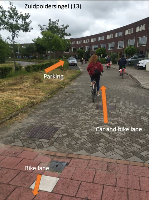
Service Road (13)
Service roads are those that connect houses together but are off of the main road. These roads felt very safe when riding down them and there are additional safety measures that make the road safer. The service roads do not connect to each other so there is a limited number of cars that travel down the roads; however, the bike lane, as seen in the picture of segment 13 at the bottom, connects to them so it is easy to bike through. This low traffic rate and low speed from speed bumps and rough pavement make the roads safer for bikers who don’t have bike lanes. The roads were made with brick paving stones, so they are not new which is why there aren’t lanes. Even though there aren’t lanes, the road serves its purpose and still is safe for bikers and people driving cars. The space is allocated to the cars and bikes. There isn’t any green space or pedestrians, but pedestrians have a sidewalk on the main road to walk on. The service roads are less expensive than other roads and still serves the purpose of allowing bikes to travel through all the service roads and cars to get to their houses.
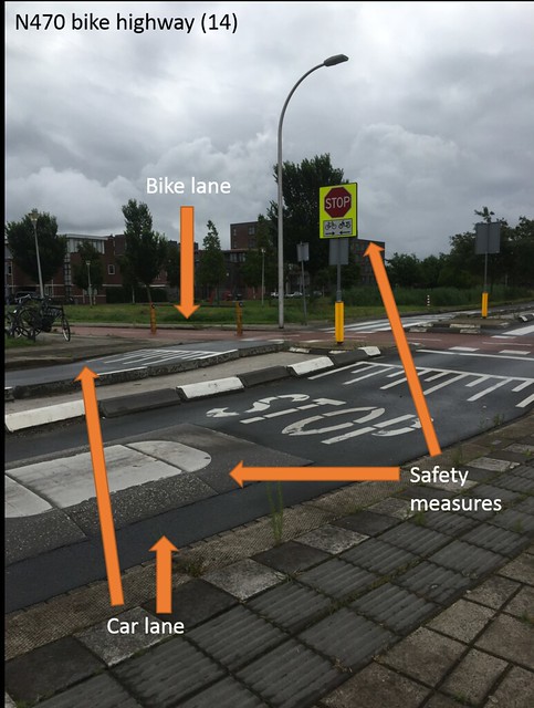
Bicycle Highway (14)
The bicycle highway is a ten-mile bikeway for bikers to use to get places quickly. When riding fast down the highway I felt at ease and safe. Except for one country road where bikers have to yield, everyone else has to yield to the bikes. In the first intersection, there are a lot of measures to stop cars and slow down bikes and mopeds. As seen in the picture of segment 14, there is a speed cushion for cars which are smaller in width than buses to slow them down and a raised crossing. Also in that picture, there is a stop sign and stop written on the ground to make sure cars are paying attention and need to stop and wait for bikes to pass. To slow down bikes there is the S-curve, but bikes don’t go as fast as mopeds so there is an inverted hump to slow those down. This was a newer road which did benefit from good planning. It allows bikes to travel for long distances fast and without stopping. In addition, the planning for the intersection was great. The measures taken to make the intersection safe for everyone was extensive and the bikers benefit. The road seems to be expensive, but if it was cheap, the intersection would not have been as safe for bikers going fast down the trail as there wouldn’t have been as many measures to stop cars.
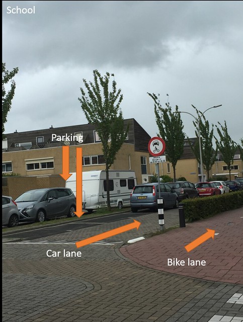
School
The school had a bike path running right next to it for kids that ride their bikes to school. Next to the path there is a median of bushes so that the kids getting out of school don’t run out into the road before looking. The road running between the median and parking is closed between 8 and 8:30 so that traffic doesn’t build up, kids don’t get hurt, and they are forced to bike to school. It is very safe around the school.
Leave A Comment