OVERVIEW
It hasn’t even been a full week in the Netherlands and already we’ve seen nearly every possible method of conveying bicycles from point to point. Here the bicycle isn’t used exclusively for a hobby – it’s a required tool for everyday life. With so many cyclists, it is necessary to put in place infrastructure that will allow for the safe and efficient flow of bike traffic amongst the many modes of transportation. The many types of paths and lanes that have been encountered so far can be grouped into the following:
BIKE LANES
In the right circumstances, bike lanes can be an effective method of conveying bicycle traffic. Bike lanes require a very low amount of effort due to the fact that they can be added to most existing roads using some paint. Although this strategy results in some of the lowest amounts of separation between bicyclists and others, it is better than nothing. Bikes are vulnerable in this setup, both due to traffic and from parked cars if present.
Buitenhofdreef and Martinus Nijhoflaan (Site 4)
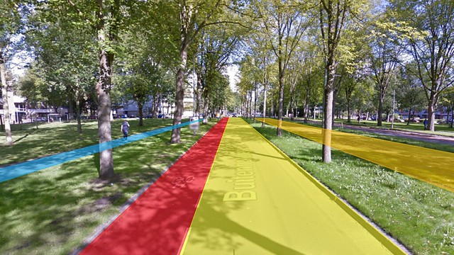
In the image above, cyclists utilize the bike lane highlighted in red. Additionally, there is a vehicle lane (yellow), a transit line (orange), and a sidewalk (blue). The pattern is mirrored on the other side of the street.
This wide boulevard conveys a two-way tram line, a lane of vehicular traffic traveling in each direction, a one-way bike lane on each side, and sidewalks for pedestrians at the bounds of the right of way. Vertical separation in the form of a curb and a line of trees separates the tram from the cars as well as the bikes from the pedestrians. This is a beautiful avenue that is incredibly green. It is a pleasant route to bike down and a bike lane seems to work here.
While this is an acceptable solution, other alternatives may also have been considered. There seems to be an abundance of space which could be utilized as cycle tracks. This would provide further separation between the cyclists and the automotive traffic and further increase safety. It would also make it much more appealing to younger and more at risk users. However after biking along this through way, I felt that it was sufficient.
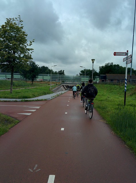
BIKE BOULEVARDS (QUIETWAYS)
Bike boulevards, which are also referred to as quietways and greenways, are roads where vehicular traffic is discouraged and bike traffic is encouraged. They utilize existing roads and create bicycle through ways by creating permeable barriers (either by an addition of bicycle connections or by the subtraction of through routes for cars) that in turn make quiet streets that bicyclists can feel comfortable on.
Buitenwatersloot (Site 7)
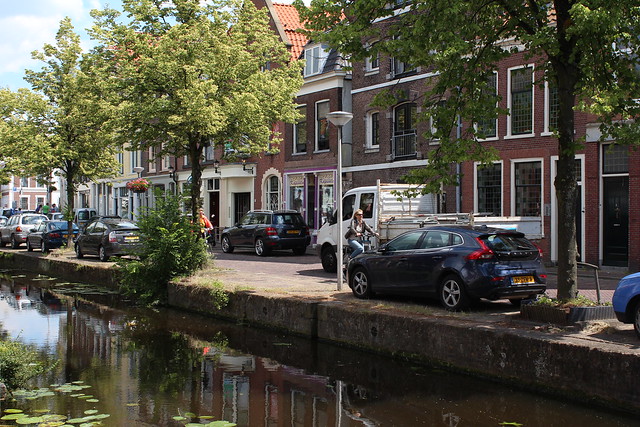
The image above shows bicyclists passing opposing traffic taken from the pedestrian side of the canal.
This site follows along a canal near the Delft train station and allows automobiles, bicycles, and pedestrians to utilize the corridor. One side of the canal is much narrower and is entirely devoted to foot traffic. The other is a one way street, and is marked “uitgezonderd [bikes]” (literally: “except bikes”), meaning cycle traffic can flow both ways. The section of interest is about a half kilometer long and around the midpoint there is a pedestrian bridge that provides a place to cross.
This narrow street has very little vehicle traffic and is dominated mainly by bicycles. When a car does go down the street, it maintains speed with bike traffic moving with it while it allows opposing bike traffic to squeeze by. While it was a tight fit, it was not overly uncomfortable. This setup was arranged with only a few signs and did not detract from the historic and picturesque nature of the corridor. This cheap solution succinctly addresses the transportation needs of the area and maintains its historic beauty.
CYCLE TRACKS
Cycle tracks can be seen as the paramount bicycling facility in terms of safety and comfort. They fully separate cyclists from vehicular traffic, transit, parked cars, and pedestrian traffic. Although this type of solution can take up a similar amount of space and is generally seen as far superior to bike lanes, a significant amount of roadway reconstruction is necessary to outfit existing routes which is costly.
Papsouwelaan (Site 6)
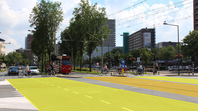
The above image shows a cross section of the avenue as bicyclists cross. The northbound cycle track is not in view, off to the left and the southbound cycle track is on the far side. Vehicular lanes are highlighted in yellow and transit lines are shown in orange.
This right of way is utilized to it’s fullest extent. Along the center lies a mixed tram line/bus lane, flanked on either side by lines of trees and a lane of traffic, followed by a row of parked cars, another row of trees, a two-way cycle track, and finally a sidewalk. The entire expanse is around 50 meters wide. I thought that this street was a great use of space and provided an excellent path through the city for all modes of transportation. The only thing that may be tough is crossing the street. A pedestrian would have to cross eight lanes of cycle, auto, and public transit before reaching the opposite sidewalk. With crossing signals this is a relatively easy task but it can take a while before the sign to cross is given.
Guys de Beerenbrouckstraat (Site 10)
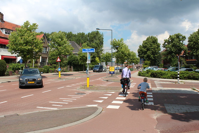
This image shows a cyclist biking past a T-intersection with their child as a left turning motorist yields.
This street successfully separates all modes of transportation and provides a safe junction where the modes meet. Bicycle traffic is routed away from vehicle traffic onto one-way cycle tracks with vertical separation provided by a curb and a line of trees. At equal grade, the sidewalk runs alongside the cycle track. This was a beautiful intersection that functioned according to plan, aided by proper signage, apt lane markings, and effective geometric design. The only thing that I think that could have been improved on was some separation between cycle and pedestrian traffic, perhaps by a small curb providing a slight amount of vertical separation.
ADVISORY LANES
Advisory bike lanes are an interesting Dutch invention that is not commonly (if ever) seen in the United States. They are intended for low vehicle traffic streets that are too narrow for cycle tracks or bike lanes. The idea behind it is this: bike lanes are established using contrastingly colored or patterned road surfaces and separated from vehicles by a dashed white line. There is no centerline. This allows for cars to drive down the center of the road allowing bikes on either side plenty of room. When two cars going in opposing directions need to get by one another they may move into the bike lanes to do so when there are no bikes in the way. This facility utilizes existing street sizes and layouts and therefore is a cheaper solution for quieter roads.
Hugo de Grootstraat, Adriaan Pauwstraat, and Westplantsoen (Sites 8 & 9)

This image shows the road at its narrowest section. A place of refuge is located in the center for crossing pedestrians. The “travel lanes” are only 1.5 meters wide on each side of the median, showing that cars and trucks have no option but to temporarily occupy the advisory bike lane in order to pass.
These two sites in the same neighborhood both used advisory bike lanes. Traveling on these narrow roads was comfortable and even when opposing cars needed to pass there wasn’t too much stress induced on riders. In the above image, it is clear to see how they truly are advisory bike lanes. At the crossing shown above, vehicle lanes were approximately 1.5 meters wide – not nearly wide enough for a car or truck. The only way a car could pass was to drift into the bike lane. The only issue I saw in this design was the possibility of getting “doored” by parked cars as there was no separation between bicyclists and the row of cars.
Schimmelpenninck van der Oyeweg (Site 12)
The image above shows cyclists utilizing an advisory bike lane. The gray vehicular travel area is too narrow for cars to pass and forces them to temporarily occupy the bike lanes.
This quiet country road is ideal for advisory bike lanes. There are few cars and the road is too narrow for true bike lanes or cycle tracks. This instance of advisory bike lanes also included road markings at intervals that forced drivers more to the center of the road, giving bicyclists more space and keeping drivers from drifting towards an edge.
SERVICE ROAD
Zuidpoldersingel (Site 13)
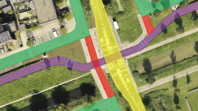
This image is an aerial view of the site. Mixed bicycle and local traffic flows on service roads (green) along through roads (yellow). Service roads are connected via bike paths (red) and the bicycle highway (purple) also crosses through.
A cross section of this right of way is comprised by a two lane through street flanked by service roads that break off at intervals to service houses. These service roads are separated from the through street by medians with rows of trees and flowers. Together, they allow traffic to move through and access a neighborhood while they also provide homeowners with a quiet road to live on. The service roads only access certain blocks of housing and are broken up to prevent traffic from flying through. In this setup, bikes utilize service roads and can travel between the vehicular dead ends via bike paths. Therefore, cycle tracks and bike lanes are not necessary. I saw nothing wrong with this setup and thought this was a great way to plan new developments.
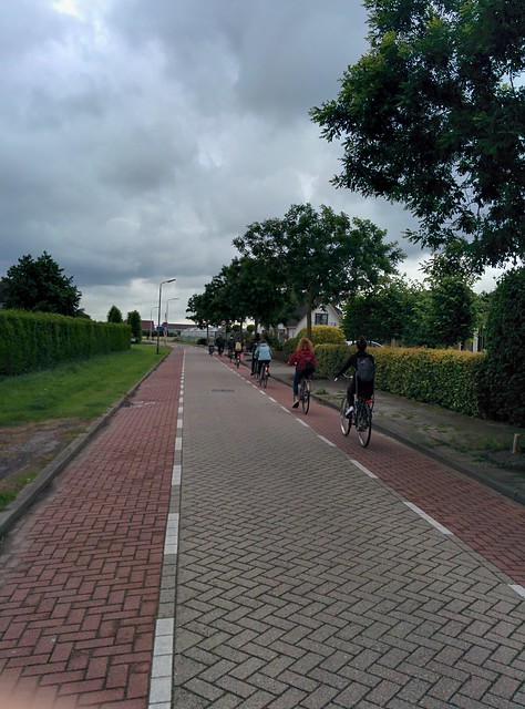
STAND ALONE PATHS
Bike highways are exactly what they sound like: main arterials for bicycle traffic to travel longer distances, e.g. city to city. Constructing a bike highway is tantamount to constructing a stand alone road so the costs are substantial. However, this facility is incredibly safe as there is no vehicle traffic at all (barring intersections) and it is amongst the most comfortable routes for users. They are not practical in urban settings as there is generally not enough space. In suburban and rural areas, they can be a great addition, running through the country, along a river, or beside a rail line.
N470 Bike Highway (Site 14)
This bicycle highway connects the Technical University of Delft to villages in Pijnacker. It runs under a highway, through a development, and through a rural area along a vehicular highway. Along its length it is generally given priority at intersections. It reminds me of rail-trails back in the United States. It provides a great route of travel for longer distance cyclists with almost no stress. I thought this was a great addition to the bike network that connects all of the area.