Topic 5. Making a Bike Boulevard
Bike boulevards are streets that are meant to share both motor vehicle and bike traffic but are also streets that provide a through route for bicycles while discouraging through auto traffic. Although most bike boulevards are one-way to vehicle traffic, they oftentimes carry contraflow bike traffic along with bike traffic following the direction of motor vehicle traffic. Bike boulevards are meant to give priority to bike traffic over car traffic. Bicycle boulevards are often designated with sharrows. They should be engineered to keep vehicle traffic slow yet provide a comfortable experience to cyclists. Bike boulevards are beneficial to cyclists because, since they are on local city streets, cyclists would be well-connected to local businesses and homes. If there were a large network of bicycle boulevards, like Portland, cyclists would be able to get around just as easily as car traffic. Bike boulevards should have some jogs in them to discourage vehicle through traffic, but not enough jogs to make the bike boulevard unappealing to cyclists.
Other measures to discourage and slow down through traffic are narrow travel lanes, parked cars, speed bumps, changes of travel direction, and blockades that only bicycles can bypass.
Some examples of bicycle boulevards in the Delft area are the Abtswoude Path, Buitenwatersloot, and Oostsingel.
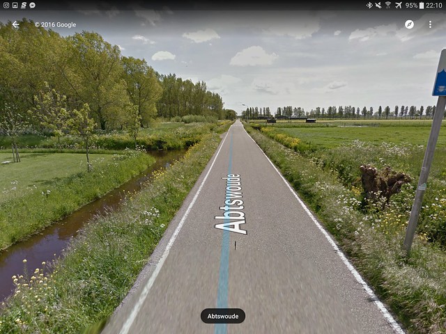
- Abtswoude Path
- The Abtswoude Path is a very long, very straight, very narrow one-lane road that runs from the southern end of Delft to the Kruithuisweg. The street runs through a very dense neighborhood and connects to many east-west bike paths that lead to other important parts of Delft. Since the Abtswoude path is very narrow, it discourages drivers from driving too fast, which would be a hazard to the drivers themselves and cyclists on the road. The street has also very little east-west connections for cars, limited its use by cars as a through street. The Abtswoude path is paved and is very smooth, and is very green and tree-lined. This provides a pleasant experience to cyclists. There are also very few lights on the road, so cyclists would not have to stop often. The road also has priority, as all the roads that intersect it must yield to traffic on the Abtswoude path already. Speed humps are another traffic calming measure used throughout the length of the Abstwoude Path. The street is a great example of a bike boulevard because it is an important through route for cyclists that provides many connections to other parts of Delft while at the same point discouraging through auto traffic.
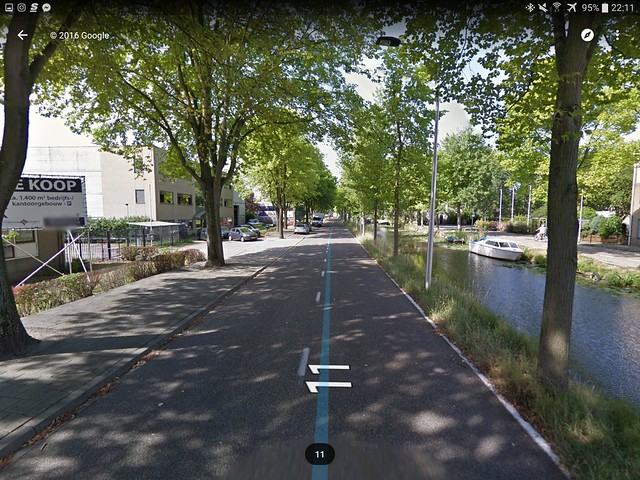
- Buitenwatersloot
- Buitenwatersloot used to be the main road along the canal in Delft. However, traffic came to be too much for this road, so a newer, larger road was built to carry the through traffic. Buitenwatersloot was then demoted to encourage vehicle traffic to use the newer road. The municipality achieved this through installing a retractable bollard halfway through the street. The bollard only retracts when a bus goes through, preventing auto traffic using the street as a direct route to the center of Delft. However, bicycles are free to pass this bollard. The narrow road also has speed humps, forcing the auto traffic to go slow. So, by installing only a bollard and some small traffic calming devices, the municipality made the Buitenwatersloot an ideal boulevard for cyclists and transit and a difficult route for auto traffic.
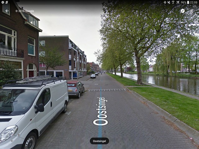
- Oostsingel
- Oostsingel was a narrow one-way street with street parking, cobblestones, and speed humps that was only open to local traffic. The street parking caused friction for the vehicle traffic, making them more likely to slow down. The cobble stones also make the cars more likely to go slow, however they are uncomfortable for cyclists, so there is a tradeoff there. Oostsingel used to be a main road, but since the construction of another, more major road, Oostsingel has been demoted. Oostsingel also implements dead ends that discourage through traffic yet these dead ends are able to be passed by through cyclists. An example of this is when Oostsingel crosses Willem Naghelstraat. Bike traffic is free to enter the road but vehicles are not. These measures all dissuade through auto traffic and promote through bike traffic, making the Oostsingel a great bike boulevard.
US Implementation of a Bike Boulevard
We chose the Shawmut Avenue corridor in Boston as a potential candidate for a bike boulevard. It runs as a mostly one way street from the busy Dudley Square area in Roxbury to downtown Boston. While Shawmut Avenue is a parallel to arterials like Tremont Street and Washington Street for most of its length, the street is mostly residential and is rather quiet. Given its proximity to parallel arterials and its residential zoning, Shawmut Avenue already fits some common characteristics to bike boulevards in places like Portland, Oregon and the Netherlands. However, there would need to be some improvements made to Shawmut Avenue in order to make it a better bike boulevard. We recommend the following improvements:
- The first would be lane dieting. At some points along its length, Shawmut Avenue has two lanes of travel that lead in the same direction (Total width is 40 feet). One of these travel lanes would need to be cut out and the affected traffic could be rerouted to parallel arterials like Tremont Street and Washington Street. To compensate for the additional space created as a result of lane dieting, an inexpensive solution would be to to make the on-street parking 45 degrees from the road (Figure I). A potential benefit to the neighbors would be that this solution provides additional parking as opposed to parallel parking. To take of advantage of even more roadway space, cars could also be parked perpendicular to the street.
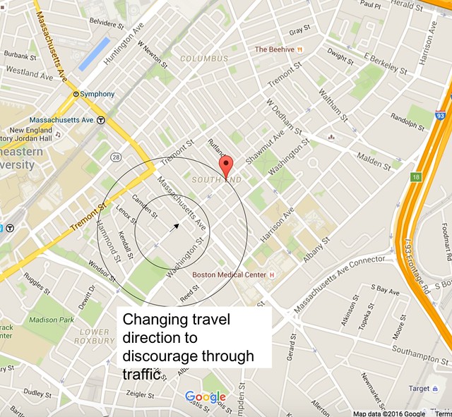
- A second improvement would be to change travel directions at points along Shawmut Avenue to discourage through traffic. Shawmut Avenue does a good job of doing this along different segments, but it could always better. Of course, a bike exception sign should be placed under the do not enter sign in order to indicate cyclists that they can ride there. We specific recommend switching the direction of travel from Lenox Street and Massachusetts Avenue (Figure II).
- A third improvement would be to install traffic calming measures as Shawmut Avenue is a straight road. These would include traffic humps, raised intersections, and if the city is feeling lavish, the bayonet (speed hump, chicane, and road narrowing all at once).
- A fourth measure would be to install proper signage. This would be to come in the form of sharrows on the pavement that indicate to the cyclist that this is a bike route. Sharrows with arrows pointing left or right would indicate to the cyclist potential destinations and routes. At other points in the route wayfinding signs could be implemented to guide the cyclist to destinations in Boston such as Northeastern University or Boston Medical Center.
- The fifth and final improvement would be to improve the design of intersections and crossings, especially at major crossings like Massachusetts Avenue and Melnea Cass Boulevard. This could be done by installing signals and marked crossings. At minor intersections the right of way could be given to Shawmut Avenue in order to prevent constant stopping.
If all these improvements were made, Shawmut Avenue would be a great candidate for becoming a bike boulevard connection from Dudley Square to downtown Boston.
Figure I
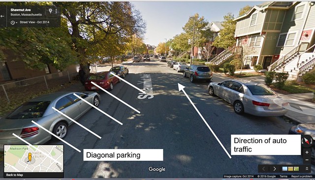
Figure II