Assignment 4: Delft Bicycling Facilities: Michael Bangert-Drowns
Bike Lanes:
Segments: 1, 2, 4
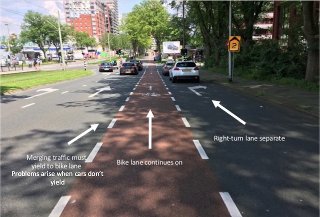
Safety and convenience: In bike lanes cyclists have the right of way in most intersections and often hold priority over cars trying to turn right (see picture). Almost all cars respect this hierarchy but several don’t, which can create near miss situations that I experienced first hand! Bike lanes are convenient as well because the they take you along the same route you would go in a car anyways, often with minimal or very short stops at traffic lights.
Tradeoff’s with how space is allocated: A bike lane was useful in the situations we visited because there either was minimal space available and relatively low traffic volume, such as in segments 1 and 2, or there was a need for separate turning lanes and other infrastructure such as in segment 4.
Relative costs: When compared to a separate cycle track the costs are much lower because it just requires repainting of the lanes on the road. In fact it’s one of the cheapest implementations of bike infrastructure, along with advisory lanes (explained below) and simply doing nothing. All of the bike lanes observed were one-way though, which requires slightly more space than a two-way lane, and therefore has a slightly higher cost for space.
General observations and how it felt: In general, it felt very safe as all the cars respected the bike lane and their requirement to yield. The only rough spots were when a car wanted to merge into the right-turn lane and forgot that she was crossing a bike lane, therefore almost hitting me. Also, the bike lane is in between the road and parking creating a possibility for “dooring,” which nearly happened as well. It felt much safer than biking in the US despite the near miss with the one car, because the cyclist has a dedicated space on the road that cars must respect, and that space doesn’t infringe on their lane so there’s no motivation to pressure the cyclist.
Segment 4: Martinus Nijhoflaan
Segment 1 and 2: Nassaulaan and Julianalaan
Bike boulevard (Quietway):
Segments: 3, 7
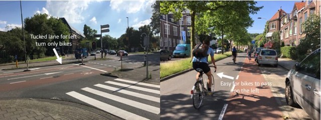
Safety and convenience: The convenience of a bike boulevard is slightly improved over the bike lanes because bikes can travel in both directions without having to cross a street or multiple lanes of traffic. For car traffic it’s only one direction, which reduces the amount of traffic friction on the street, thereby also increasing safety for cyclists.
Tradeoff’s with how space is allocated: We weren’t able to stop long enough to take pictures of segment 3, but we learned that segment 7 used to be a major thoroughfare for traffic between Delft and Den Hoorn. Seeing this street now, I can’t imagine how it handled any large amount of car traffic in the past, mostly because it’s so thin. So using it as a major bike thoroughfare and only a local through street for cars in one direction seems like a much more efficient use of space. Having one side designated for pedestrians even further reduces the traffic friction on the bike and car side of the boulevard.
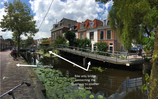
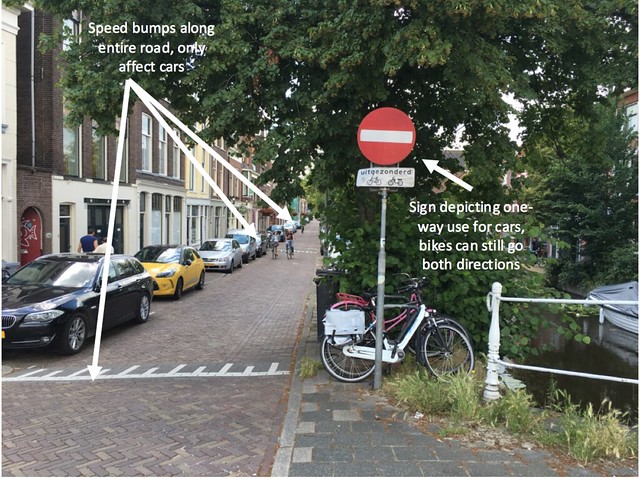
Relative costs: This setup has very minimal costs due to the fact that only speed bumps and signs had to be put up to slow car traffic and inform bikers they could only use one side of the street. The bridge probably cost a lot of money, but that is not a required aspect of a bike boulevard.
General observations and how it felt: I really liked this street because the bikes had a lot more room to maneuver and there wasn’t a lot of car traffic. I felt safe all the time and also enjoyed the fact that I didn’t have to watch for pedestrians because they were on the other side of the canal where bikes were only allowed for local traffic. The pedestrian only side also seemed slightly bumpier so that it was more inconvenient for bikes to use, but I don’t know if that was intentional or if that side just wasn’t redone when the street was reconfigured.
Segment 7: Buitenwatersloot
Cycle tracks:
Segments: 5, 6, 10
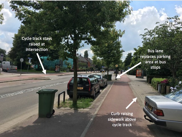
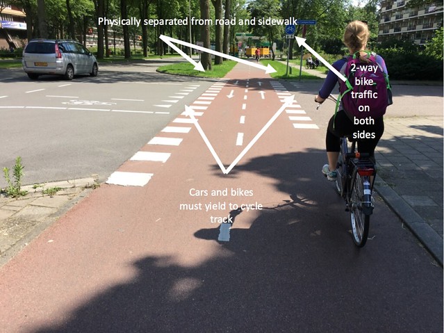
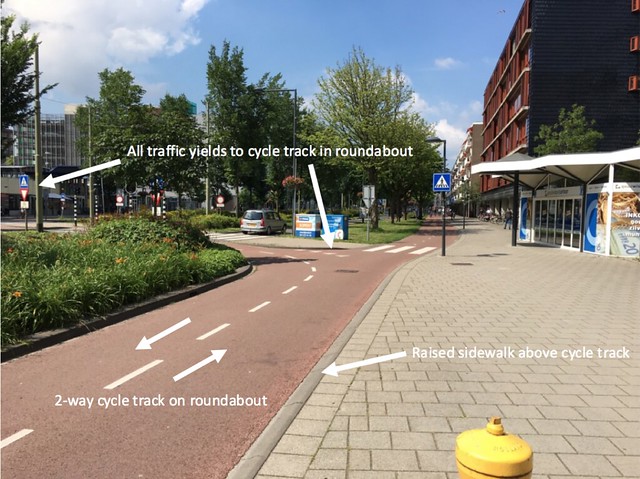
Safety and Convenience: The cycle tracks are the safest form of bicycle infrastructure in my opinion. They’re completely separated from traffic which reduces the interaction between cars and bikes to just the intersections. In the case of segments five and six, the right of way is completely given to the cyclist. This is most convenient when you come to the intersection between Martinus Nijhofflan, Papsouwelaan, and Voorhofdreef, where there’s a traffic circle that gives complete seniority to the cyclist. Because intersections are the most dangerous area of cycle tracks it’s very important to engineer them to be as safe as possible. This complete seniority and very clear signage at the traffic circle solves this safety problem. Another interesting aspect of the cycle track in the traffic circle is that it is two ways, making it an incredibly convenient intersection for bikes, one of the most convenient I experienced. The raised crossing also makes intersections safer by visually emphasizing the seniority of the cyclist.
Tradeoff’s with how space is allocated: Segment 10 was redone 10 years ago, so it is very interesting to see how space was redistributed from the former 2×2 lanes. The road is the lowest part of the street, about 23 feet wide, and separated by a median. The street has parking on both sides which is sometimes replaced by a bus stop, and is bordered by a curb with trees. This area is about 9 feet wide on both sides. After the parking comes a raised one-way cycle track which is about 7 feet wide and stays raised while crossing intersections to visually reinforce its right of way. Farthest out is the sidewalk for pedestrian use. This arrangement provides space for all forms of transportation with very little interaction between them, allowing traffic to move without much interruption.
Relative costs: These streets would be very expensive to make because they require total reconfiguration of the road space. However, they are the safest for cyclists because they provide physical separation from the cars and so are good for roads with high ADT.
General observations and how it felt: The cycle tracks were my second favorite facility to ride on only to bicycle highways. It felt very safe, very well marked, and very efficient and convenient due to the fact that it runs right along a major road you would normally drive on.
Segment 10: Ruys de Beerenbrouckstraat
Segment 5: Voorhofdreef
Segment 6: Papsouwselaan
Advisory lanes:
Segments: 8, 9, 11, 12
Safety and convenience: Advisory lanes are right on the road and actually share space with cars, and so increase possible interactions between cyclists and vehicles. However, advisory lanes are mostly implemented on streets with a very low ADT (dead ends, country roads, small residential streets) so this makes them still a very safe option. Even on some streets with a higher ADT, advisory lanes give cyclists a place to bike without majorly inhibiting the flow of traffic. Again they’re very convenient for the biker because they’re right along a street they might normally be driving on. They can also provide connections between other more major bike routes which can be more convenient and safer than biking on a road without any biking infrastructure.
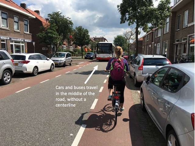
Tradeoff’s with how space is allocated: Advisory lanes are very useful on roads that have a very small width. This is because the bikes and cars share the same space. One of the most important aspects of the advisory lane is the lack of center line which allows cars to drive in the middle of the road and only move into the advisory bike lane when they encounter an oncoming car. Despite the car being able to drive into the advisory lane, the experience is still very safe and there’s a very clear priority for cyclists in that space.
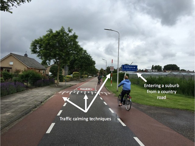
Relative costs: The advisory lane is also among the cheapest options for bike infrastructure, right along with the bike lane. This is because all that needs to be done is repaint the road. Nothing needs to be repaved in order to implement the changes. The only added costs is that traffic calming devices need to implemented on the country roads as the approach the town such as in segment 12.
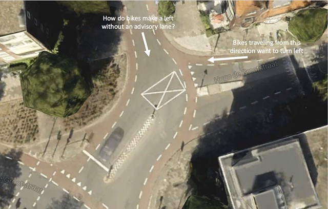
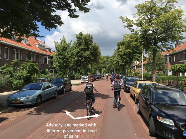
General observations and how it felt: Advisory lanes felt very safe to me because there was hardly any traffic on the roads. This made it even easier to pass other cyclists than it was on bike lanes. Cars seemed very comfortable using the road as well, easily driving in the center of the road and using the advisory lanes only when necessary.There was one intersection at the end of segment 8 that was somewhat confusing on how bikes should make a left turn. There was one street with advisory lanes that wasn’t an actual segment, but was very interesting because it used different pavement to designate the advisory lane instead of paint. Unfortunately we didn’t get to segment 11.
End of Segment 8: Hugo de Grootstraat

Segment 9: Adrian Pauwstraat
Unnamed Advisory Lane
Segment 12: Schimmelpenninck van der Oyeweg
Service Road:
Segments: 13
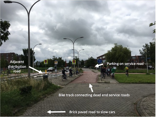
Safety and convenience: The safety of service roads is incredibly high. This is because no through traffic travels on service roads and bumpy brick pavement on many of them along with speed bumps on all of them keep car speeds low. The convenience of the service roads is even more paramount in my opinion because even though a service road may be a dead end for a car, it is connected with a track for bikes, allowing them to travel more efficiently. It’s also much safer than driving on the adjacent distribution road which has higher speeds.
Tradeoff’s with how space is allocated: Service roads mean that there is less space for lanes in the distribution road. However, because parking takes place on the service roads, the flow of traffic actually improves despite the lower number of lanes.
Relative costs: Service roads are probably right in the middle as far as costs go because they require paving with bricks and construction of connecting cycle tracks.
General observations and how it felt: I thought the service roads were one of the coolest implementations of bike infrastructure just because of all their built in functions. They reduce traffic friction on distribution roads, create bike infrastructure without separate cycle tracks, and slow down traffic just through the type of pavement used and small traffic slowing treatments.
Segment 13: Zuidpoldersingel
Bicycle Highway:
Segments: 14
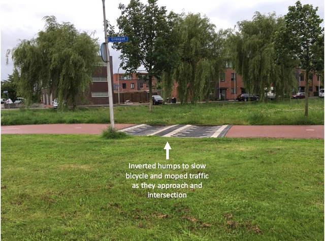
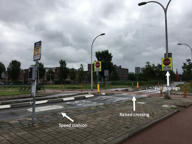
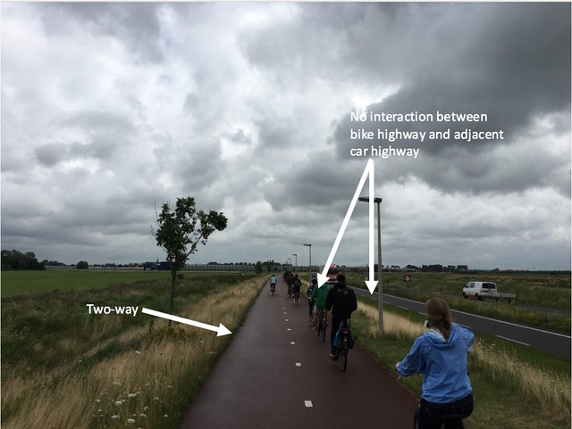
Safety and convenience: The bike highways are by far the safest of the bike infrastructure options. They’re completely separate from all other forms of traffic and have right of way in the few situations they do cross a road. There are lots of features controlling both the speed of the bikes and the speed of the cars as they approach an intersection. Inverted humps slow down bikes and especially mopeds. Full stop signs (instead of the usual yield) slow down cars along with speed cushions and a raised crossing for bikes. Because they’re separate from roads, they could be slightly more inconvenient depending on where you want to go. Or, if you’re looking for a quick way to travel long distances on a bike they can be incredibly convenient
Tradeoff’s with how space is allocated: The only space that bike highways take away from are possibly parking lots or housing areas. They’re only about 10 feet wide total though so don’t take up much space. Because of their direct nature though, sometimes land has to be bought or changed to make way for the bike highway. This often results in the development of small parks though, so it’s not bad at all.
Relative costs: One of the more expensive bike infrastructure implementations just because of its size. Probably still cheaper than a road retrofitted with cycle tracks though.
General observations and how it felt: I absolutely loved the bike highway, it was very peaceful to bike on and safe the entire way. The only issue was that on the way back the headwind was very strong because the highway was raised above the surrounding area.
Segment 14: N470 Bike Highway
School Biking Infrastructure:
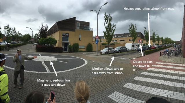
On the way home we passed a school that had some very interesting features for bicycle safety. Due to the high vulnerability of children to accidents the school and the town took extra precautions. First off, they closed one side of the road to cars from 8:00 to 8:30 Monday-Friday. This would that side up for strictly bicycle usage so beginner riders wouldn’t get hit as they started to pedal. Secondly they added a row of hedges between the school and the street so that students wouldn’t run right into the road, as well as adding a 1-2 foot wide median so that cars could park in the center of the road and get rid of the dangers accompanied with children running out from between parked cars. Thirdly they added a giant speed cushion to the intersection right by the side of the school to slow cars down, giving them more time to react to unpredictable children as well as read the other restrictive signs.
THE END