Assignment 4: Delft Bicycling Facilities: Alexander Tang
Bike Lanes
Location #4 Buitenhofdreef, Martinus Nijhoflaan
This road segment has bike lanes on the roadway similar to those in the US. Located in the median are tram tracks in separated from the roadway with fences and curbing. The roads have average width vehicle lanes with bike lanes painted on.
The bike lanes did not feel as safe as cycle tracks because they were integrated with the vehicle traffic. Cars were passing by at medium speeds and at the stoplight I was a foot away from vehicles in the right turn lane and the straight through lane. The lack of cycle tracks may be explained with a lack of right-of-way or the treeline being so close to the roadway. These bike lanes seem relatively inexpensive because they were just painted on the asphalt. As a tradeoff they are not as safe as cycle tracks. These bike lanes also did not seem as convenient as other facilities because they were on the roadway and did not have as many points of ingress and egress.
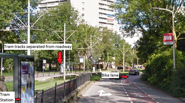
Photo depicting the tram line with roadway, bike lane, and sidewalk.
Bike Boulevard
Location #7 Buitenwatersloot
This location consists of a one way street with bike lanes, a canal, and a pedestrian only street. Signs at the beginning of the road segment clearly state which mode of transport is allowed to travel there. There are side streets that would have fed into the street in the past but now have been converted into dead end streets. These side streets are more car friendly and can be found with multiple parked cars on the sides.
This street segment provides safety by providing bike lanes and a narrow vehicle lane causing drivers to travel slowly. The slow speed of vehicles travelling down this road made me feel at ease though not as at ease as I would have felt on a dedicated bike path. Though, given the historical nature of this street and the limited space with the canal and buildings, this is the best that could have been provided short of closing the road off to cars. This segment provides convenience to cyclists by connecting parts of the old town to Coenderstraat.
This facility is inexpensive as the lanes are just indicated by pavers that were placed perpendicular to the rest on the sides of the road. These pavers would not have to be replaced like paint and may remain there until reconstruction of the road occurs. It does a good job of showing cyclists that they should travel in the advisory lane but be advised that there may be cars that pass close by or intrude when needed.
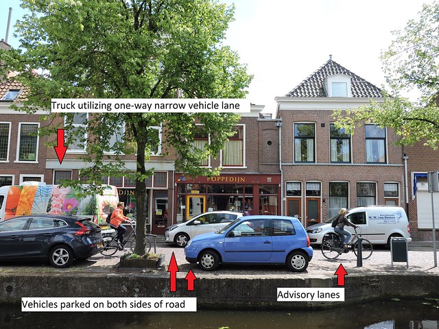
Photo depicting contraflow of bikes against vehicle traffic. The bikes are travelling on advisory lanes.
Cycle Tracks
Location #5 Voorhofdreef
This road segment has separated bike lanes and four lanes of vehicle traffic, 2 in each direction. The opposing lanes of traffic as well as the roadways and cycle tracks are separated by tall trees.
These cycle tracks provide maximum safety through being physically separated from the roadways and having trees between the travelling bikes and cars. The cycle tracks are two-way allowing cyclists convenient access to their destinations without having to cross the street. I felt very safe riding through here. This segment of cycle track could have been expensive but I feel it was worth it in order to provide a high level of security and comfort to cyclists. If the bike lanes had been part of the road, I feel that it would not have felt as safe for the riders with two lanes of cars passing them.
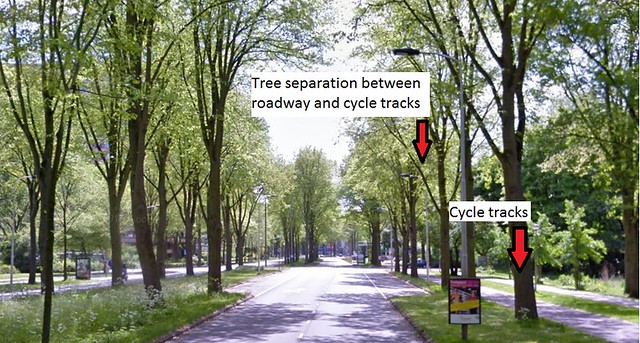
Photo depicting the parkway with trees separating roadways from cycle tracks. Trees also provide good shade on hot summer days.
Location #6 Papsouwselaan
This road segment has separated cycle tracks which are parallel to the roadway alignment. The segment consists of tram tracks in the center separating the opposing lanes of traffic with cycle tracks on either side followed by a sidewalk. The cycle tracks felt very safe to ride on since they were separated from the roadway by a grassy median. This design benefits from good planning because the roadway is separated far away enough from the cycle track that cars that turn into driveways or sidestreets have enough of an approach that they can see approaching cyclists or pedestrians and vice versa. These cycle tracks may have been expensive to install, however they are much safer for those that use them and provide convenient access to the buildings and stores located adjacent to the road.
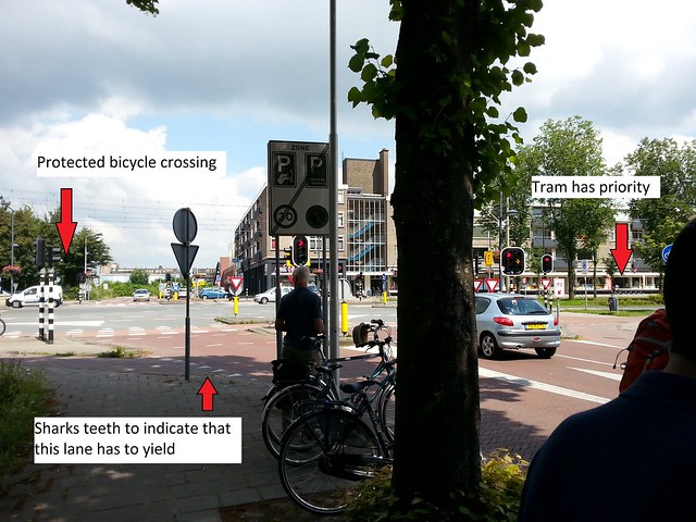
Photo depicting the protected intersection of tram, vehicles, bikes, and pedestrians. The tram seems to have priority to pass through the intersection is it is public transit.
Location #10 Ruys de Beerenbrouckstraat
This segment has cycle tracks separated by vertical alignment and curbing. The bicycle crossings are indicated by medians and signs and are difficult to miss. Sharks teeth also work to indicate to vehicles and bicycles that they need to yield at certain points. I felt safe while riding on this cycle track because of the slow speed of traffic and the separation of the track from the roadway. This design may have been impacted by right-of-way constraints but the designers seem to have been able to fit a reasonable amount of sidewalk and cycle track on this stretch of roadway between the properties next to the road. This cycle track may have been expensive as it requires being at a higher grade than the roadway and separate facilities. It is worth it as cyclists feel safer having their own path as opposed to sharing the roadway with vehicles. Slow speeds on the road may also provide cyclists with a sense of safety as vehicles pull into driveways because they are travelling so slow and will be able to see and yield to cyclists when turning. This cycle track is also convenient to cyclists because it allows easy access to the houses along the road as well as a pretty straight cycle track with low degree curves.
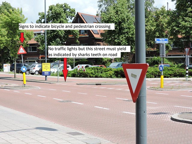
Photo depicting intersection with a side road and several bicycle and pedestrian crossings.
Advisory Lanes
Location #8 Hugo de Grootstraat
This street segment was in a neighborhood reminiscent of a suburb. The vehicle travel lane was narrow and there were advisory bike lanes on both sides of the road. I felt relatively safe while travelling down this road, however, when two cars had to pass each other, one car had to intrude into the bike lane. This could have been dangerous if either the driver or the cyclist were not paying attention and a collision could have occurred. However, this intrusion into the bike lane is by design and allows the road to accommodate two directions of vehicle travel without providing two whole lanes. This segment provides safety by having the narrow roadway limiting speeds and by having a low speed limit. The cars pass cyclists at a speed which does not scare them. This design also allows for roadside parking. The advisory bike lanes seem to have been inexpensive as they are were painted on the roadway. Some parts of the lanes had already faded but that can easily be remedied with another coat of paint.
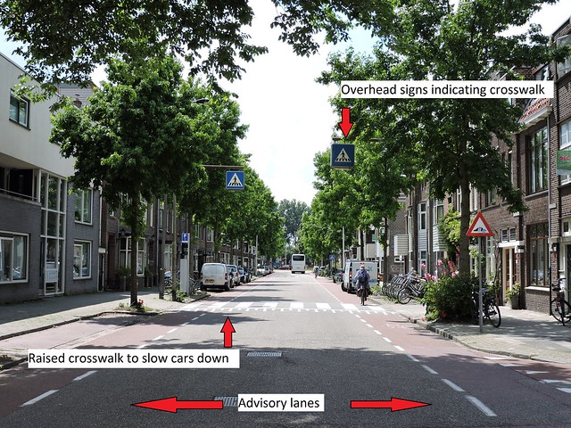
Photo depicting advisory lanes on both sides of the road as well as parallel parked cars. Raised crosswalk works to slow vehicles down while travelling down the road.
Location #9 Adriaan Pauwstraat, Westplantsoen
Similar to Location #8, this street segment was located in a suburban setting. The vehicle travel lane was narrow and there were advisory bike lanes on both sides of the road. I felt pretty safe on this advisory lane, however, when a bus drove past me at the crosswalk it passed by really close (within inches) and that felt a little less safe. The raised median in the middle of the street has arrows indicating a chicane to drivers and cyclists. This serves to further limit speeds on this road because it is a physical obstruction in the path of vehicles. This makes them more likely to heed it. The cyclists benefit from the chicane in the middle of the road because this works to slow traffic on the street down. The advisory bike lane facility may have been inexpensive as it is composed of just paint on the roadway. The ease of access to the lanes and houses next to the roadway provides a lot of convenience to those travelling in this road.
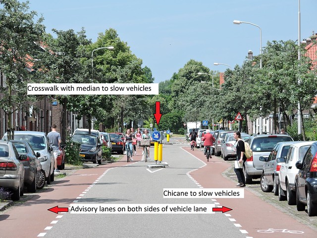
Photo depicting a chicane with crosswalk and median. Advisory lanes are on both sides of the roadway next to the parallel parked cars.
Location #12 Schimmelpenninck van der Oyeweg (Delfgauw)
This segment is a rural country road with light traffic and trucks that service farms adjacent to the road. Advisory lanes line both sides of the road and give cyclists space to travel while allowing cars to move down the road and pass each other by intruding on cyclist space if needed. I felt pretty safe on this segment of road. When there were little to no cars, it felt like a wider cycle track and when the occasional vehicle did pass by, they usually veered into the opposite advisory lane in other to give me more of a buffer. Cyclists benefit from this good design by getting their own space because it has been recognized that traffic is so low on this road that giving vehicles all the space would have been a waste. To implement these, it seems like it would have been inexpensive as all that was needed was red asphalt and paint for the striping.
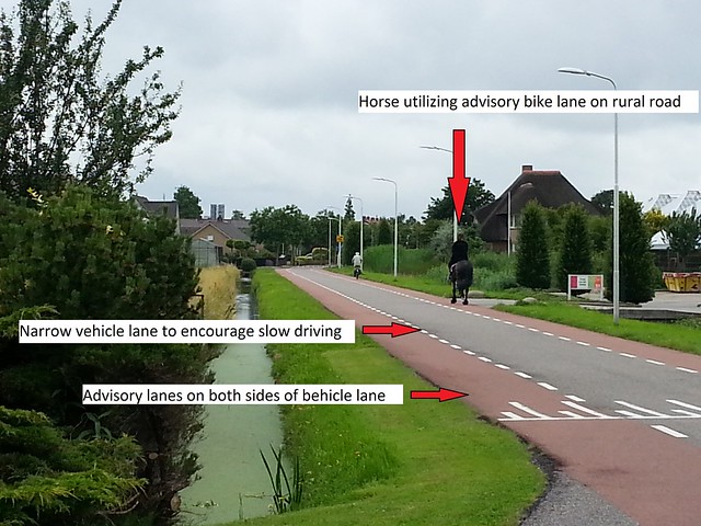
Photo depicting advisory lanes on this rural country road. Light traffic allows cyclists to feel relatively safe while vehicles pass by.
Service Road
Location #13 Zuidpoldersingel (Delfgauw)
This bike facility is located on a surface road which gives access to houses lining a major road without having the homeowners deal with the higher traffic on the major road. This segment would have cycle tracks continuing the path of travel whenever the service road would end. I felt safe while travelling on these service roads because the vehicle traffic was light and slow. Part of the reason for such light and slow traffic was because the service roads do not form a continuous path and only service a number of houses. This dissuades drivers that would seek an alternative road to the major road from using service roads. The cycle track bridge was also very pleasant to ride on top of. Cyclists benefit from good design because being able to ride on these service roads is a better alternative than riding on the major road with more traffic and faster speeds. This facility may have been a more expensive option since they are new and separate roads that need to be built parallel to the major road. Cycle tracks also had to be built in order to connect portions of the service roads together.
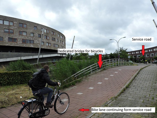
Photo depicting a cyclist crossing a small bridge over water on the cycle track connecting portions of service roads.
Bicycle Highway
Location #14 N470 Bike Highway (Delfgauw)
This segment goes along a rural highway and is separated on both horizontal and vertical alignment. Part of it follows the vehicle highway while part of it goes off onto its own alignment through farmland and suburbs. The bicycle highway felt extremely safe to ride on because it was separated from the highway and cyclists got priority at intersections. By having its own alignment though farmlands, this facility allows cyclists to feel safe and move at their own pace while cruising though intersections with ease. This goes a long way in providing peace of mind and allowing cyclists travelling along the highway to not have to worry about intersections. This particular facility allows a cyclist to travel approximately 10 kilometers without stopping. There was also an underpass where cyclists travel under a highway instead of having to deal with an intersection which would have been very dangerous. This may have been very expensive as new pavement would have had to be installed and construction would have had to be done on untouched land. However, all this comes together to provide cyclists with a safe and relatively easy ride while on this bicycle highway.
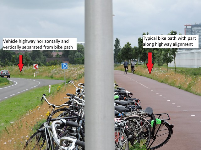
Photo depicting both the bicycle highway and vehicle highway. Horizontal and vertical alignment separation can be seen with the bicycle highway being elevated.
Bonus locations:
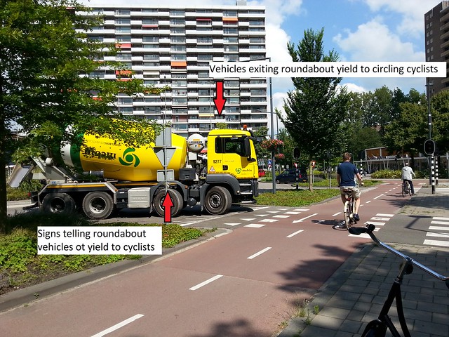
Roundabout located between Vorhoffdreef and Papsouwselaan.
Photo depicting an intersection between a roundabout exit and the bike path that circulates around the roundabout. Vehicles exiting the roundabout must yield to circulating bicyclists. There are also pedestrian crossings and the design of the roundabout limits excessive speed from circulating motor vehicles. Sharks teeth indicate to exiting vehicles that they must yield to bicyclists on the bike path.
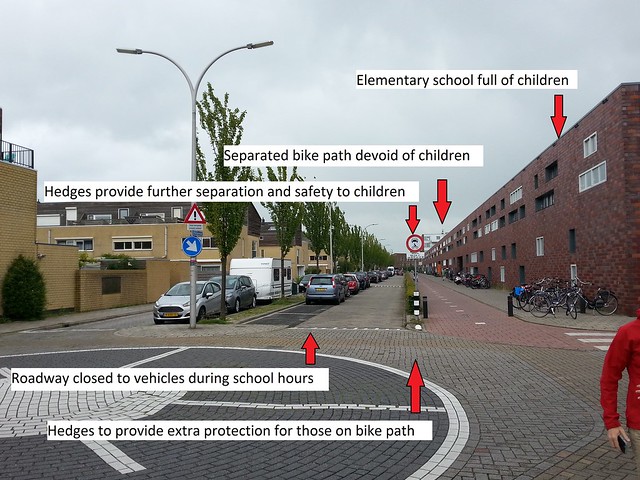
Bike Path and Street outside of Elementary School
This was an extra location we visited while on the way back to TU Delft. The brown brick building is an elementary school which reaches down the entire block.
The standard bike path in front of the school is used by school children in the mornings and afternoons and provides a safe path for them to commute on. For added safety and peace of mind there has been a row of hedges planted to safeguard the bike path from the roadway. Also, the regulatory sign on the right side of the roadway informs motorists that car traffic is not allowed during school hours providing an added layer of safety for the children.