Introduction and Overview:
Lozerlaan is a main road in the southern part of The Hague that completes the ring road network that allows access to different areas in The Hague. It separates the southern residential areas from the recreational areas of De Uithof and Madestien and the economic center of the Westland. From the Google earth view, the east of the residential areas is the traditional Den Haag city area, the citizen would probility use to go shopping in this area. And the Lozerlaan is also an important route to the new economic centres of the Westland (there has a lot of greenhouses and auction in this new business zones). Actually, this road has a 2+2 travel lanes in each direction and the transit medium is quite broad for people who want to cross the road to the recreation areas. Lozerlaan is becoming a natural barrier for both people, plants and animals, and it would have a negative impact for the process of new economic centres of the Westland. Meanwhile, traffic volumes at the Lozerlaan would increase after the opening of the A4 motorway between the Hague and Rotterdam at the beginning of 2016, so the traffic risk of this road would be increased, and it also be complained with the traffic users and pedestrians.
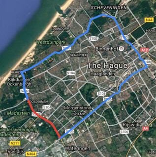
Lozerlaan (red) as part of the greater Hague ring road network (blue)
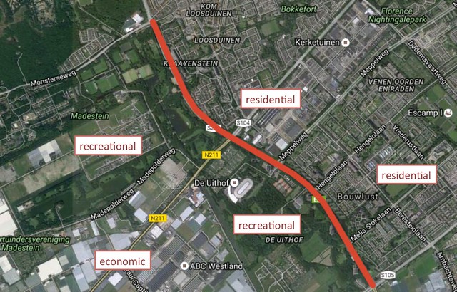
Segment of Lozerlaan creating separation between recreational, economic, and residential areas
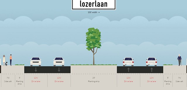
Typical cross-section of Lozerlaan
Objective:
To improve connectivity between residential areas in the southern region of the Hague and recreational and economic areas in northern edge of Westland, while simultaneously improving through traffic along the Lozerlaan segment of the Hague’s ring road network.
Design Proposal:
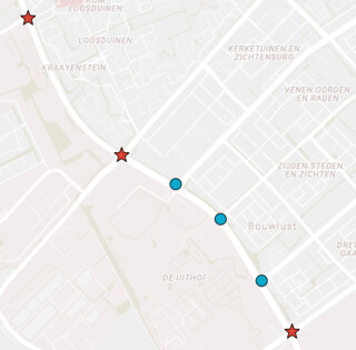
Lozerlaan will continue as a bypass road for through traffic like the adjacent Wippolderlaan segment. To improve land access, while creating these bypass segments all intersections will be redesigned. The Lozerlaan corridor has six signalized intersections. For vehicular traffic, our main concern, these can be separated into three major intersections (Erasmusweg, Nieweweg, and Monsterweg – portrayed as red stars on the map below that serve route connections and three minor intersections (Melis Stokelaan, Hengelolaan, and Meppelweg – portrayed as blue dots on the map below) that serve mostly local access. No proposals are made to existing segments between intersections as they seem to serve the main purpose of the road.
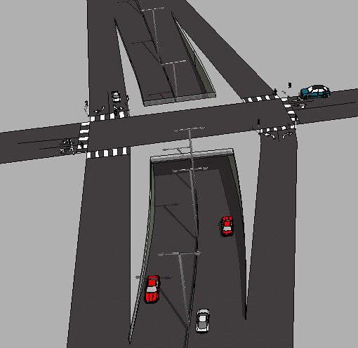
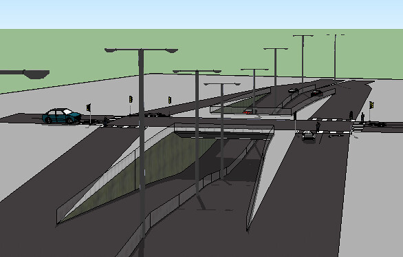
Major Intersections
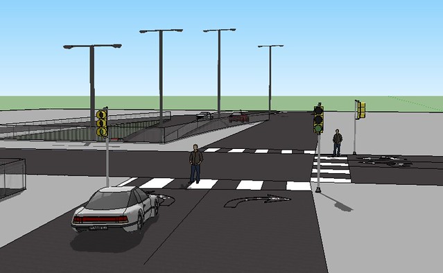
To improve vehicular through traffic movements at these locations, Lozerlaan will be an underpass crossing with entrance and exit ramps. These ramps will take the place of the existing turn lanes for Lozerlaan, as they will no longer be required. Crossing streets will be maintained at existing grades. There is already an adequate number of existing lanes at crossing streets to accommodate the required left and right turns onto ramps. Pedestrian and cyclists facilities will also be maintained, with signalized crossings at ramps so that they can safely cross and continue along the crossing streets. For underpass segments, any grass medians will be replaced with double-sided guardrail medians. This will allow ramps more space within the existing limits, and thus reduce amount of adjustments to existing cycle tracks alongside Lozerlaan.
Minor Intersections
Proposed designs at minor crossing will require an underpass crossing for Lozerlaan vehicular traffic, while all crossing streets will be maintained at grade. At minor intersections no exit or entrance ramps will be provided, allowing the through traffic to continue unimpeded. Since all turning movements will be removed at minor intersections, road widths can be reduced or adjusted as necessary to accommodate traffic. Trams crossing at Meppelweg will be grade separated from Lozerlaan and will not be affected by the proposed design.
The benefit of the bypass road:
From the Google traffic condition view, the traffic condition of the whole road has a little congestion in the peak hour, and the congestion is focused at intersection areas. In order to increase the traffic volume of these areas and also eliminate the barriers between the residential areas and recreation zones, the traffic bypass would be an ideal choice if there are no strong land use controls.
Though the access ramps may suffer some congestion it would allow the through traffic to continue at speed because there do not have signal light underneath. The maximum speed of Lozerlaan would be increased from 50 km/h to 70km/h without any traffic calming treatments and through traffic travel times would be decreased. Safety of pedestrians and bikers might be increased as well, the highway from south to north would be physically separated from the bike path and sidewalk. When pedestrians are crossing the intersection they only need to consider the turning phases. The grade separation also provides the people who live or visit the area a better connection. People from the residential areas, such as, Kerketunen or Morgenstond can easily access to the Westland, beach, shopping centres and some other businesses while avoiding disrupting the through traffic along Lozerlaan.
Meanwhile, bypass roads, have also environmental and economic consequences. On the one hand, they reduce noise and pollution emissions along the previous route. These improved intersections will reduce the amount of vehicles waiting for the light in each intersection. On the other hand, Lozerlaan would be more attractive because the easier people go to the economic centers of the Westland, the more economic consequences the Westland would get. The redesign of Lozerlaan will increase the connectivity between the Westland and Den Haag.