Bicycling facilities in Delft
Delft and its neighboring cities and villages have many facilities in place to make bicycle transit a pleasant, safe, and efficient experience. Below, I give examples and annotated illustrations of places where Delft planners have applied a number of different treatments, to both existing and newly developed infrastructure.
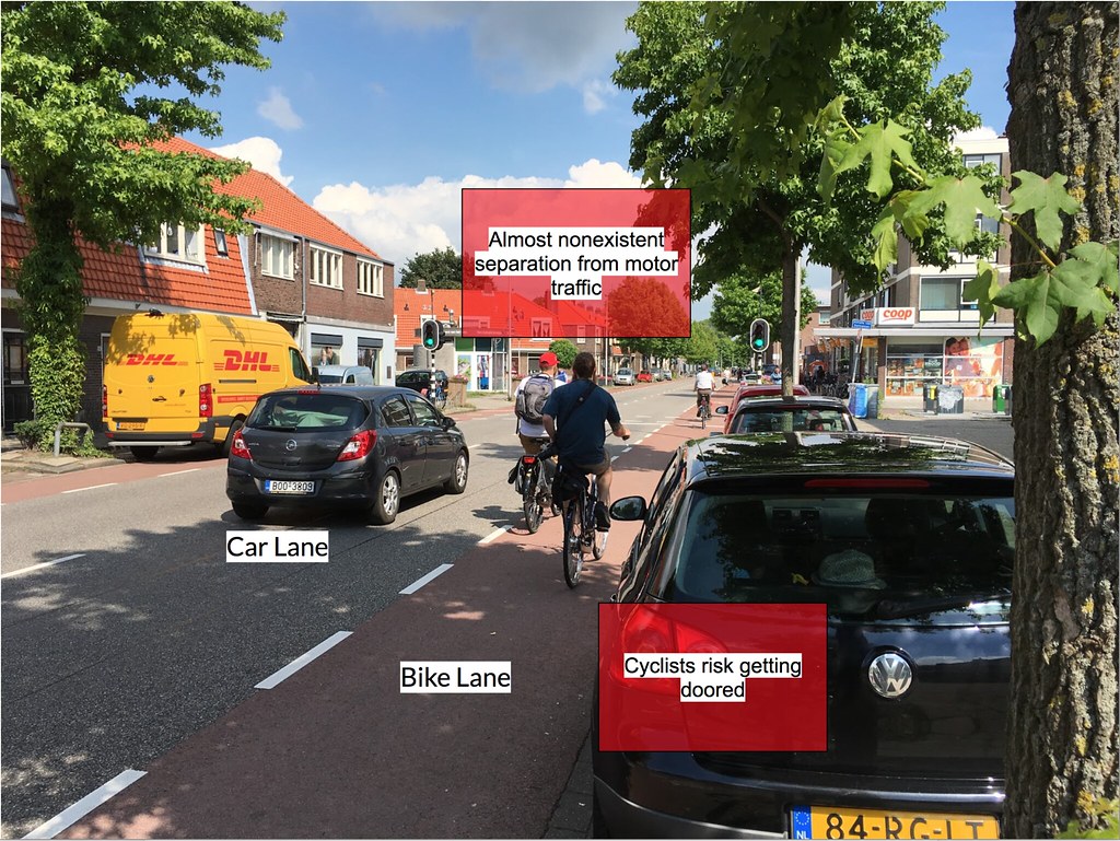
Bike lane
Bike lanes are defined as a dedicated lane for cyclists, directly adjacent to a car lane on the main roadway. The bike lane is usually the one closest to the road shoulder, and tends to be narrower than the car lane(s) due to bicycles’ narrower profile. These provide a reasonable amount of safety from motor traffic, but are not preferable over cycle tracks. In the Netherlands, bike lanes are permitted only on 1+1 streets (1 lane of motor traffic in each direction).
The first example photo is an older street that was retrofitted with bike lanes. This implementation is very cramped due to the limited road width the engineers had to work with. The bike lane is directly adjacent to car traffic on the left and car parking on the right, introducing a risk of injury on either side. This road causes a fair amount of traffic stress for cyclists. The bicycle facility here is relatively cheap compared to other Dutch treatments, as it is just paint and a different paving material. It serves its function as well as it can for this road, until car parking can be removed and a better cycling facility introduced.
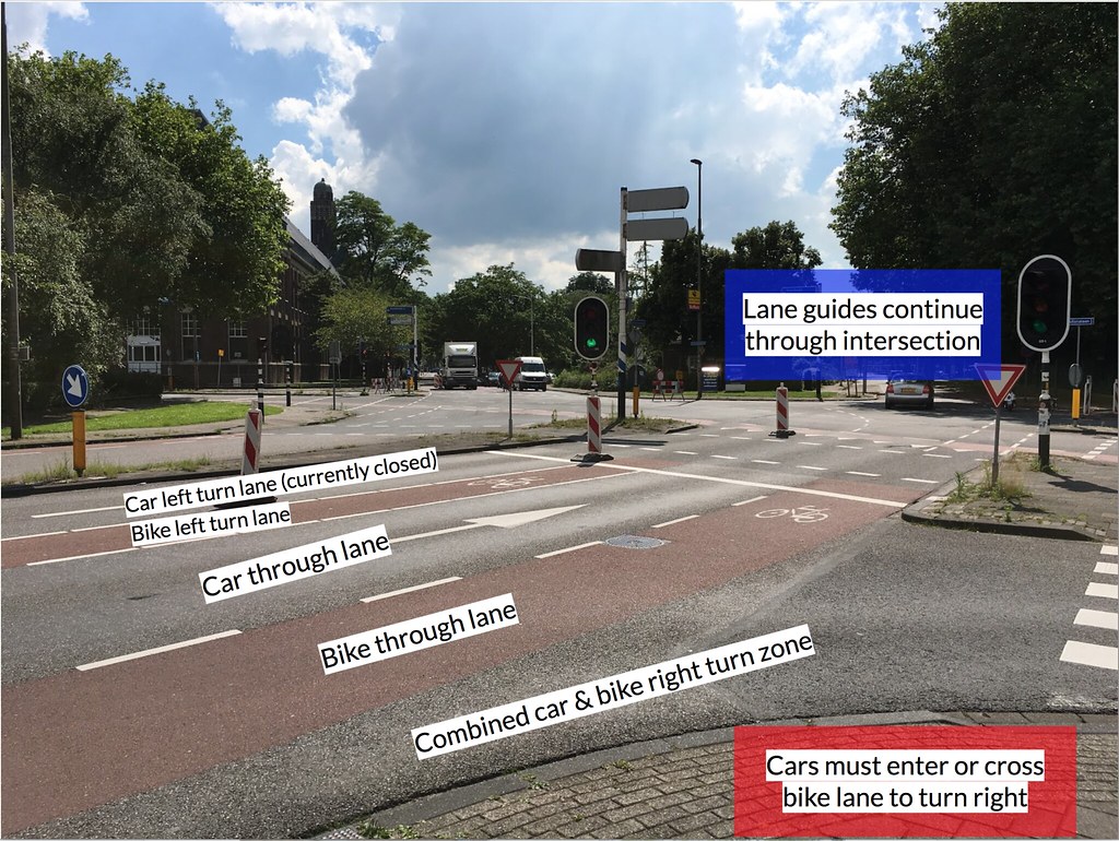
The second example photo is another retrofitted older street. At this intersection, the bike lane splits into one for cyclists going straight through and one for those making a left turn, interleaved with the same lanes for cars. The right turn lane is shared by both vehicle types. This layout is not especially safe. It does little to separate cyclists from car traffic and forces cars turning right to invade and cross through the straight bike lane. Since it is just paint and a different paving material, again it is a cheap solution.
Bike boulevard
Bike boulevards are roads that mainly cater toward cyclists, but also allow cars in small numbers. These are usually residential or side roads that do not get a lot of car traffic by their nature. They provide a good level of safety for cyclists.
In the example photo, the road has little car traffic and no separator line, allowing cyclists to freely use it. It is wide enough to comfortably accommodate several cyclists in either direction. Since this street is low on car traffic and plenty wide, it requires little work to implement safe bike infrastructure. The facility consists of a paved road and not much more, and is presumably quite cheap. It serves its purpose well.
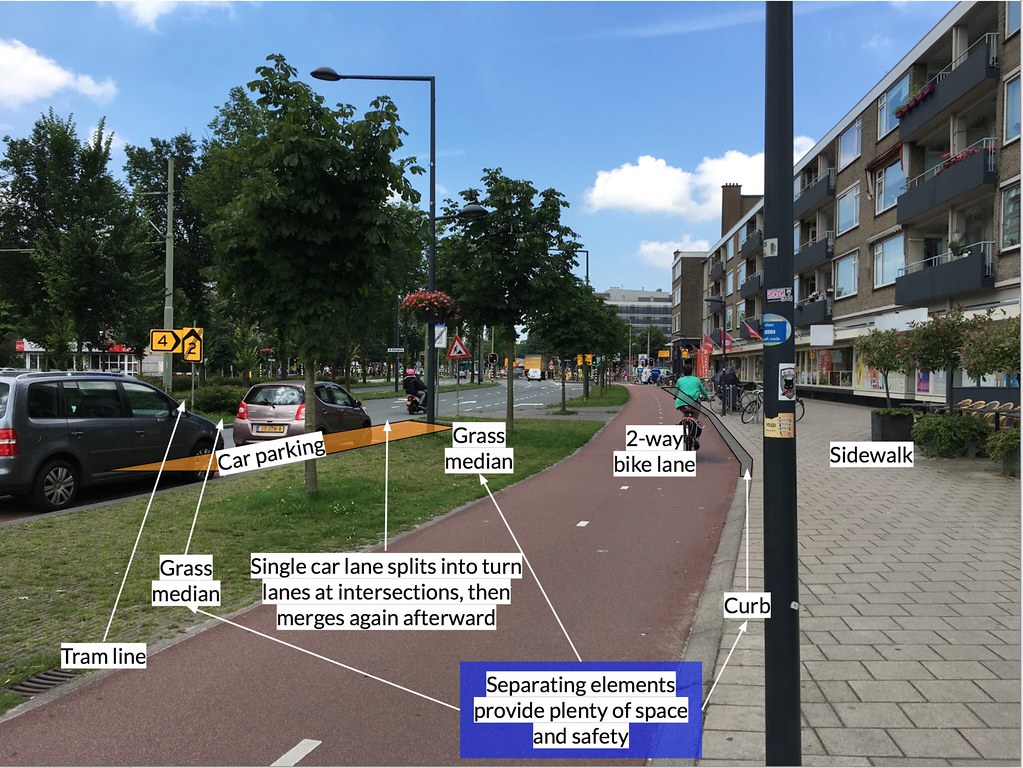
Cycle track
Cycle tracks are bike routes that are physically separated from motor traffic by some sort of barrier. These are one of the safest bike facilities, as they only interact with motor traffic at intersections in a very controlled manner.
In the example photo, we see a road consisting of, from center moving outward, a tram line, a single car lane, car parking, a 2-way cycle track, and a sidewalk. All of these features, including the unmentioned barriers, are mirrored on the other side, making this a very wide street. This street originally had 2 car lanes in each direction, but was demoted to 1 in favor of safer bike and pedestrian crossings and overall calmer traffic, due to lack of passing lane. Each element is physically separated from all of the others by a barrier. The car lane is separated from the tram line on its left by a raised grass median, from the cycle track on its right by parking and another raised grass median. The cycle track is raised above the car lane at the level of the median, and separated from pedestrian traffic by a small curb. This layout results in excellent safety for all parties. In the distance is an intersection with car and bike traffic lights on different cycles; when the bike light turns green, it always allows cyclists to make a left turn by crossing two sides of the intersection. Given the large amount of space available for the road, the designers of these facilities were able to provide a safe route for all, but with a considerable pricetag.
Advisory lane
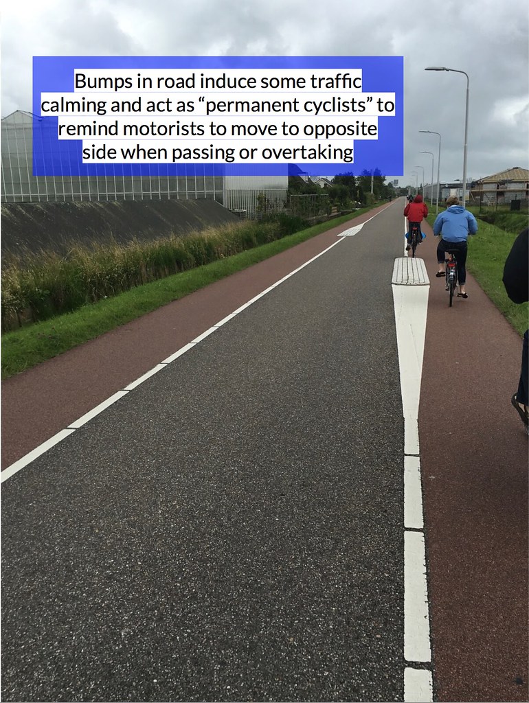
Advisory lanes are used extensively on rural roads. They consist of two bike lanes on either side of the road, with a slightly less than car-width space in the middle. The roads are two-way for both types of traffic, and their design “suggests” that drivers use the center of the road when alone, but shift into one bike lane or the other when they need to go around a cyclist or another car. These roads are surprisingly safe and comfortable for drivers and cyclists, and are usually on straight stretches so that drivers can see any obstacle from far away and act on it. Traffic calming features are also placed to keep drivers from speeding too much. This facility is about as cheap as regular bike lanes, and allows roads to keep their original size.
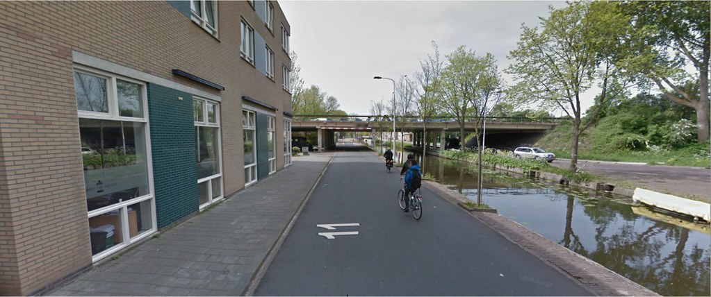
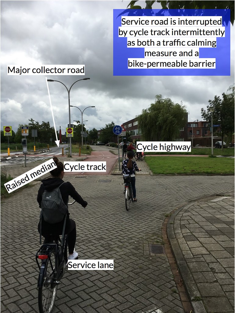
Service road
Service roads parallel major arteries or collectors where residences have popped up, so that drivers going home do not need to slow down abruptly in fast traffic to turn onto their residential street. To stop motorists from using a service road to avoid traffic in the main road, barriers are put in place at regular intervals to interrupt through traffic between sections of the service road. In the instance of the example photo, the road ends and a smaller cycle track connects it to the next segment. This carries the benefit of allowing cyclists to use the calmer service road as a contiguous cycle path. This facility is not cheap, as it adds a full-size road in each direction parallel to the original high-volume road, but it does a good job of separating the slower cars, heading to or from home, from the faster through traffic. It also provides a safe bicycle route.
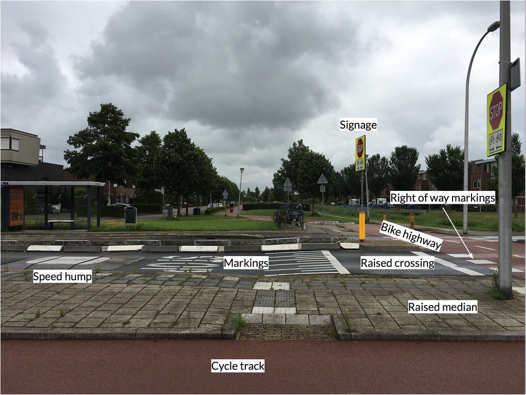
Bicycle highway
Bicycle highways are long-distance, standalone cycle tracks that connect major cities. They have right of way at intersections almost without exception. Since these are an entirely separate facility from car routes, they are one of the most expensive to build, but they allow cyclists to travel further, even commute, in total safety.
The example photo shows the intersection of the cycle highway (starting at bottom right, continuing to background) and the major collector road pictured in the photo for service roads. To make it crystal clear that bikes have right of way at this crossing, there are many warnings and road features in place. A speed hump, a STOP road marking, a raised crossing, STOP signage, and clear right of way markings leave little doubt to drivers what they are supposed to do at this intersection. Building all of these was certainly not cheap, but makes this crossing very safe.
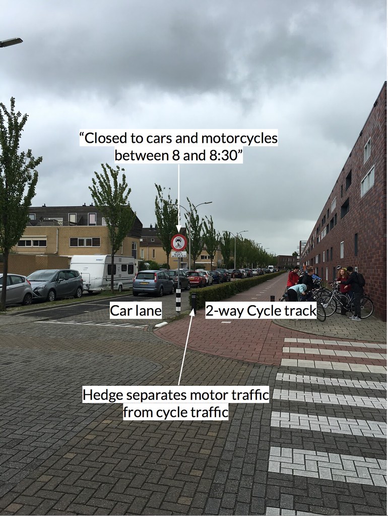
Bonus: Elementary school precautions
Outside this elementary school, the city has been careful to make sure children do not accidentally run out into car traffic. Instead of the usual curb, raised median, or row of occasional trees separating the cycle track from the car lane, they put in medium-height hedges that make it very difficult for kids to cross the line. In addition to this, they have banned all motorized traffic on the street between 8:00 and 8:30am, the period where parents previously dropped their children off in their cars. This ensures that no motor traffic will use the street when it has the most children on it.