Current IMP Projects

CAMPUS DISTRICTS

Campus Subdistricts

The proposed IMP projects have been grouped in a series of campus precincts that recognize the relationship between the interventions and the existing campus patterns of development and open space. While each of these precincts is geographically distinct, each district, and indeed each project, endeavors to improve the campus, as a series of interconnected spaces and buildings.

In many cases, each precinct has its own distinct architectural character, mix of uses and public spaces, or is delineated by its relationship to the public realm. The IMP proposes that each new development within a given precinct will positively contribute to the physical setting of the existing neighboring context, enhance the existing streetscape, infrastructure and pedestrian environment.


The proposals will allow for greater pedestrian accessibility throughout the campus while overcoming the campus ‘super-block’ condition to the surrounding neighborhoods on both sides of the tracks.

Each master plan proposal is to be considered within the broader context of the campus and the abutting neighborhoods with the campus systems of pedestrian routes, their related improved street crossings, vehicular/ delivery and trash collection routes all considered as part of this wider network.

Core Campus

+

Cabot Hall

  • Location: 400-402 Huntington Avenue
  • Site Size: 2.25 Acres
  • Existing Uses: Student Athletics / Recreation
  • Proposed Uses: Academic / Student Life / Cultural/ Parking/ Commercial
  • Proposed Height: 10 to15 Stories
  • Development Size: 400,000 to 500,000 GSF
+

Forsyth Hall

  • Location: 70 Forsyth Street
  • Site Size: 0.75 Acres
  • Existing Use: Northeastern University faculty building
  • Proposed Use: Academic
  • Proposed Height: 8 to 12 Stories
  • Development Size: 140,000 to 150,000 GSF
+

Science Quad

  • Location: 336 / 288 / 334 Huntington Avenue
  • Site Size: 1.88 Acres
  • Existing Uses: Academic (Sciences) / Facilities
  • Proposed Uses: Academic (Sciences)
  • Proposed Height: 7 to 10 Stories
  • Development Sizes: 60,000 to 100,000 GSF

Core Campus

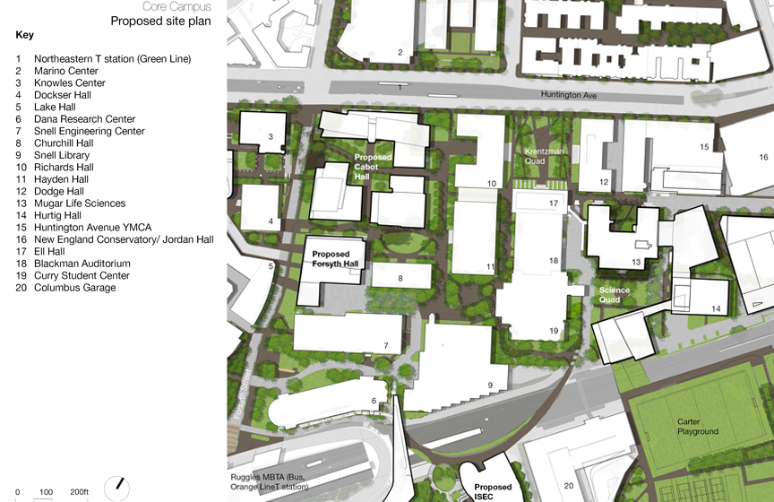
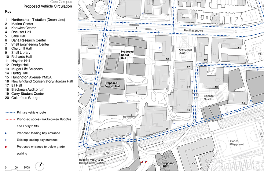
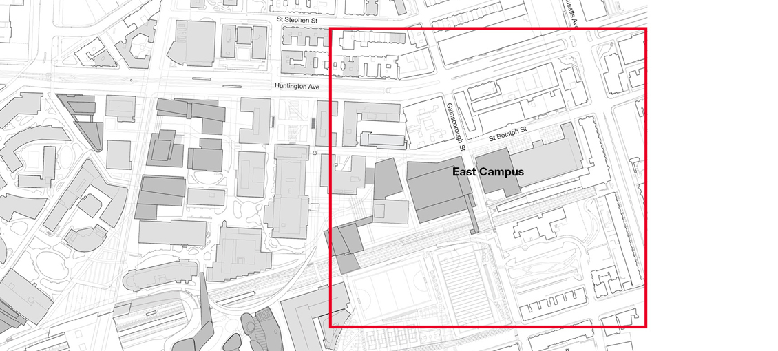
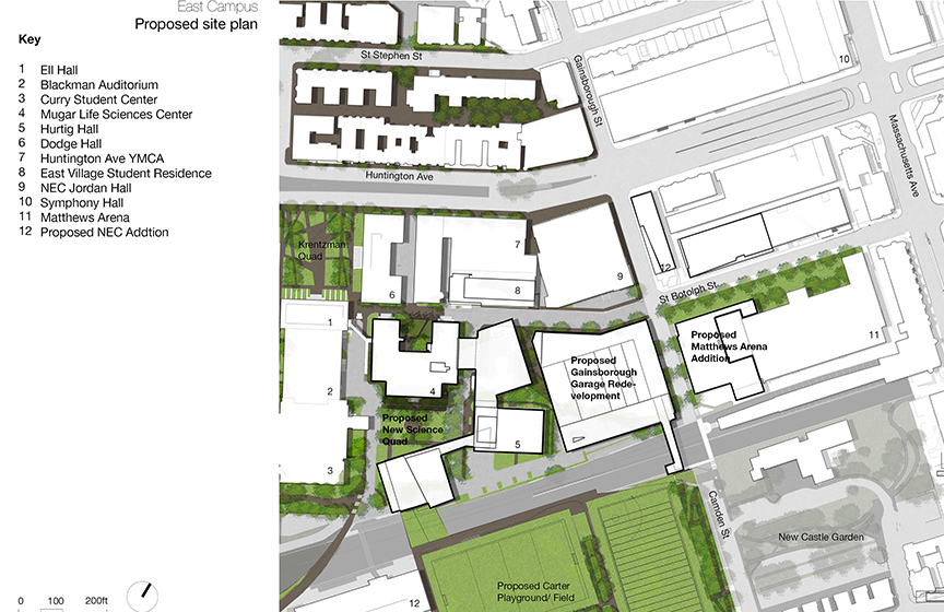
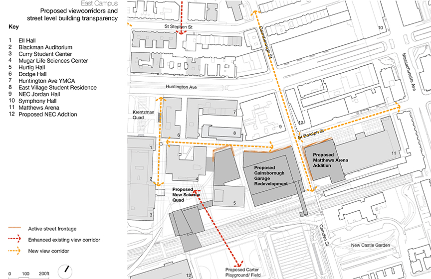
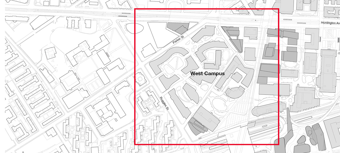
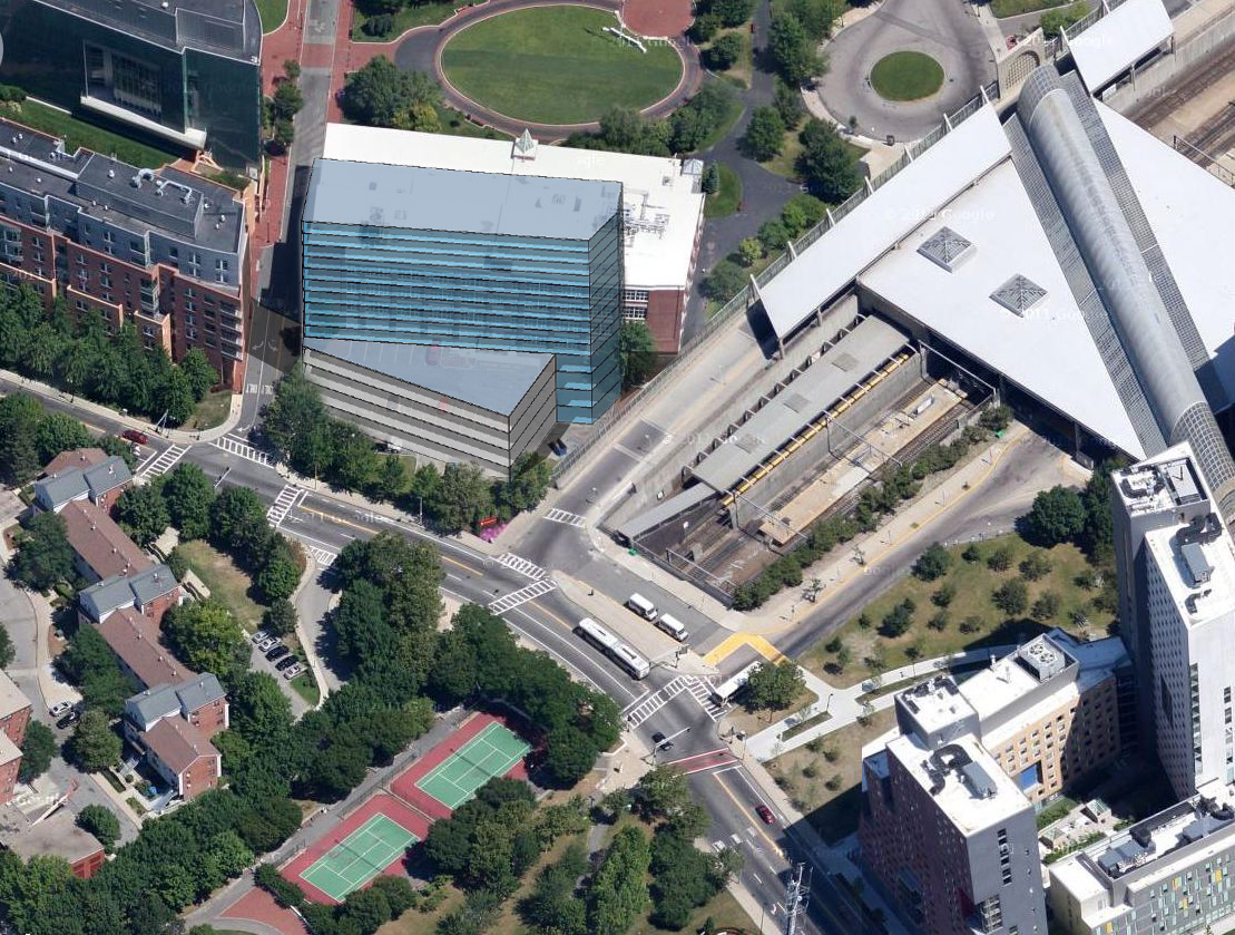
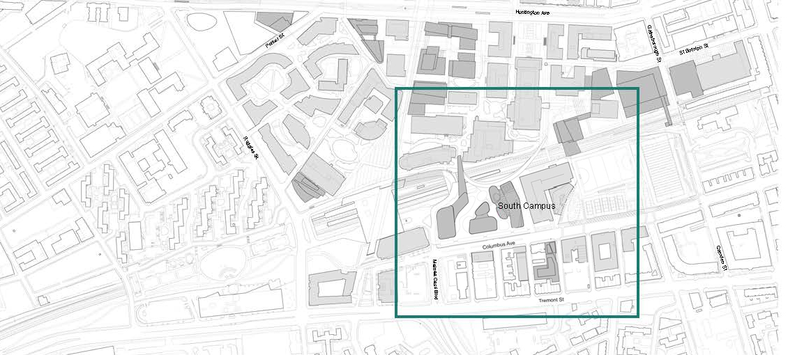
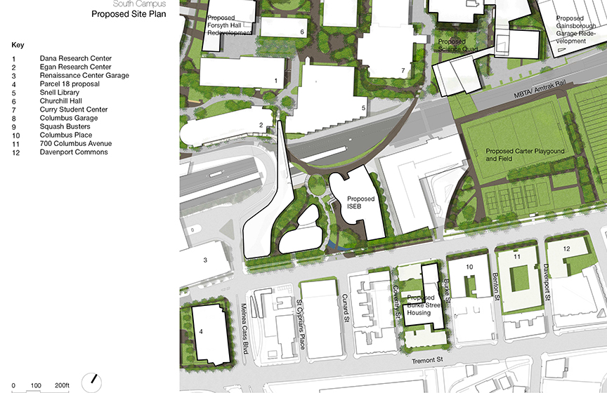
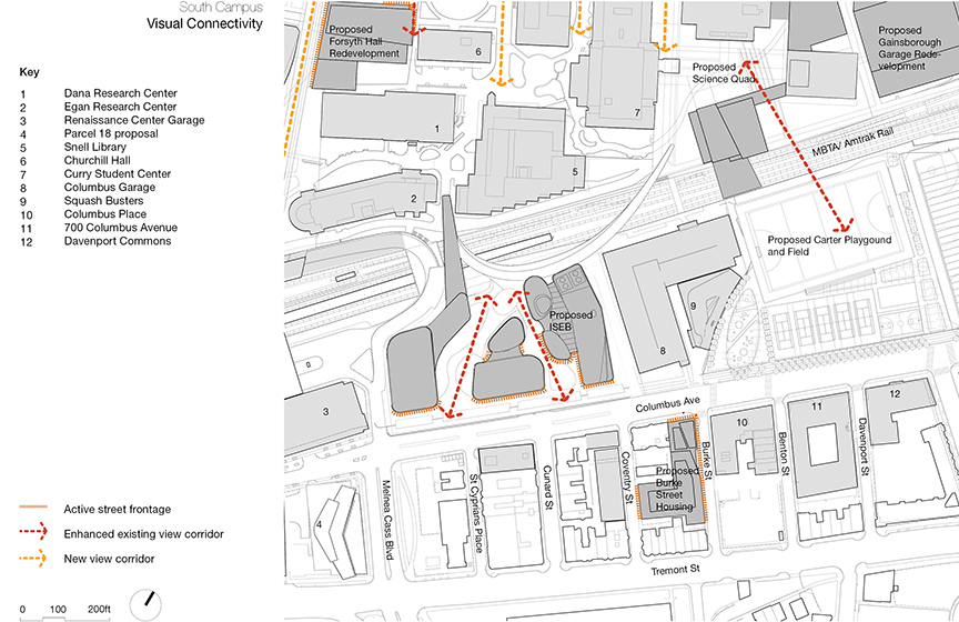
The proposed development here presents significant opportunities to improve the public realm of two important city streets: Huntington Avenue and Forsyth Street.  The redevelopment of the Science Quad will allow for the creation of new frontage on St. Botolph Street across the street from the new GrandMarc housing (now under construction). 

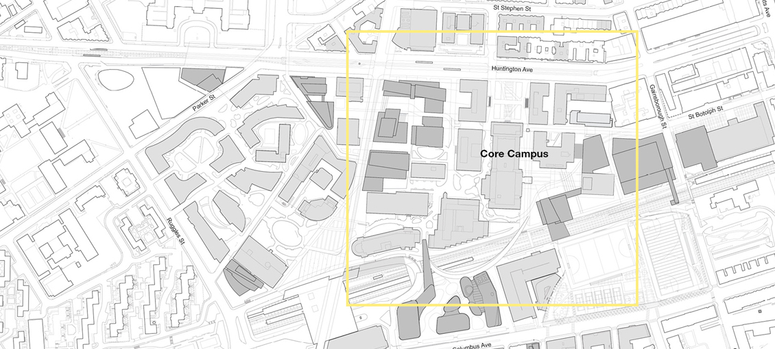
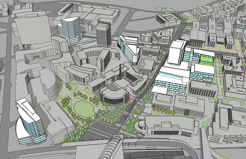
All of the proposed Core Campus projects are enabled by the phased demolition of three existing facilities: Forsyth Building, Cabot Athletic Center and Cullinane Hall. Forsyth (built in 1926 and acquired by NU in 1949) and Cullinane (built in 1911 and acquired by NU in 1930) were both originally industrial buildings that have been repurposed by the university multiple times. While they have served the Northeastern well, they are not particularly well suited to contemporary academic uses and both are only two stories in height.

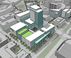
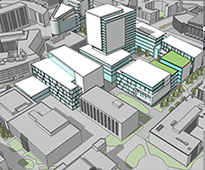
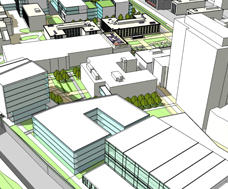
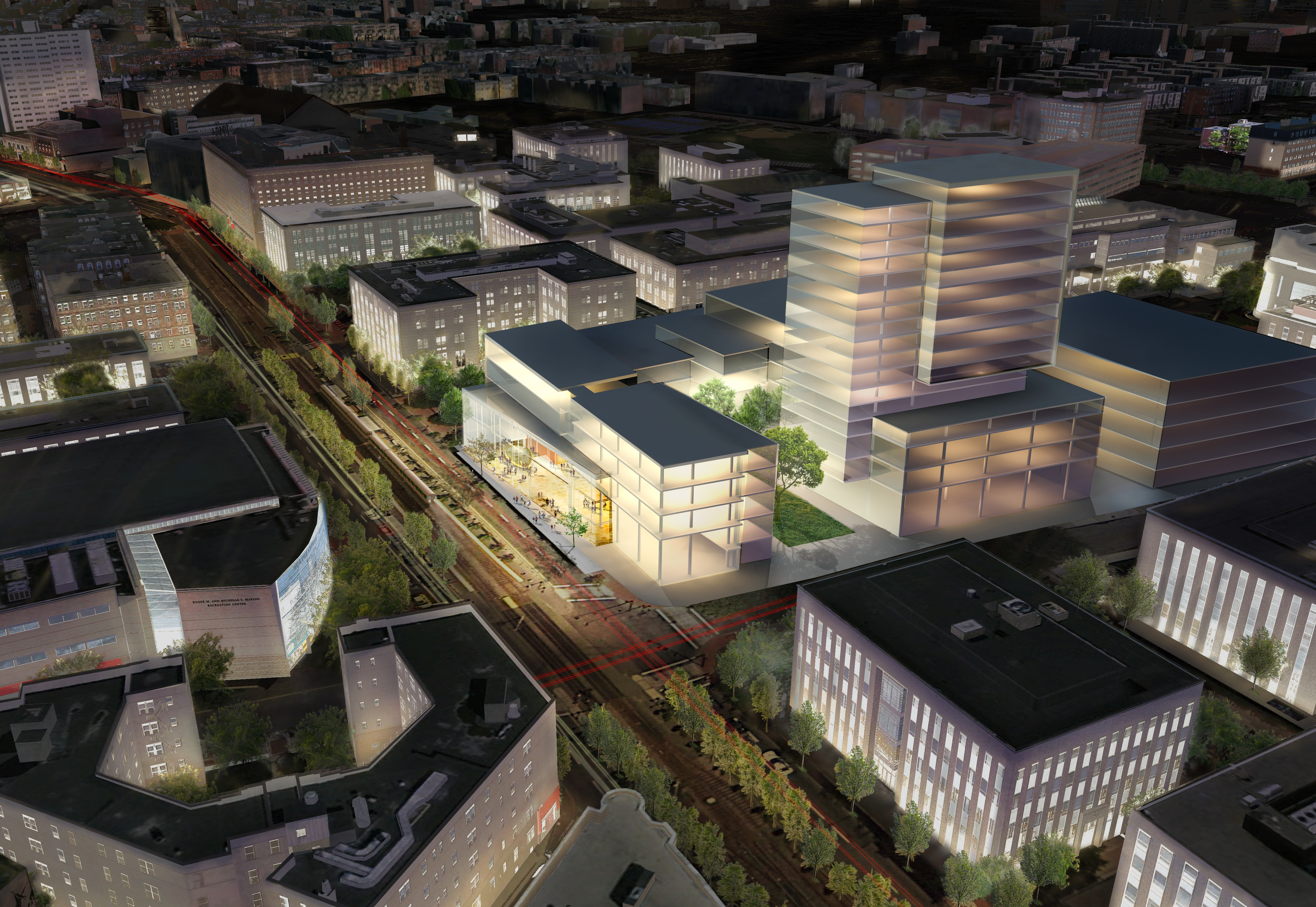
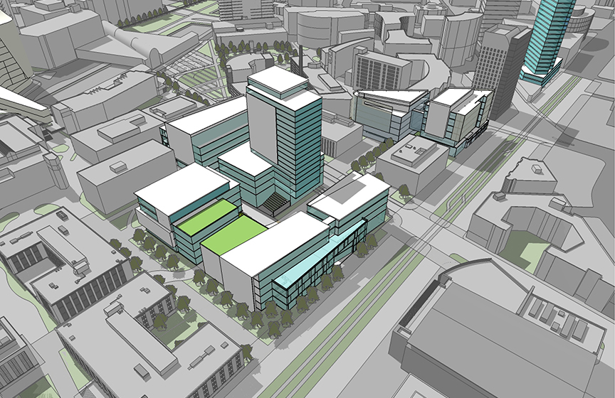
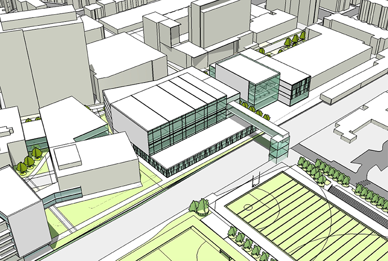
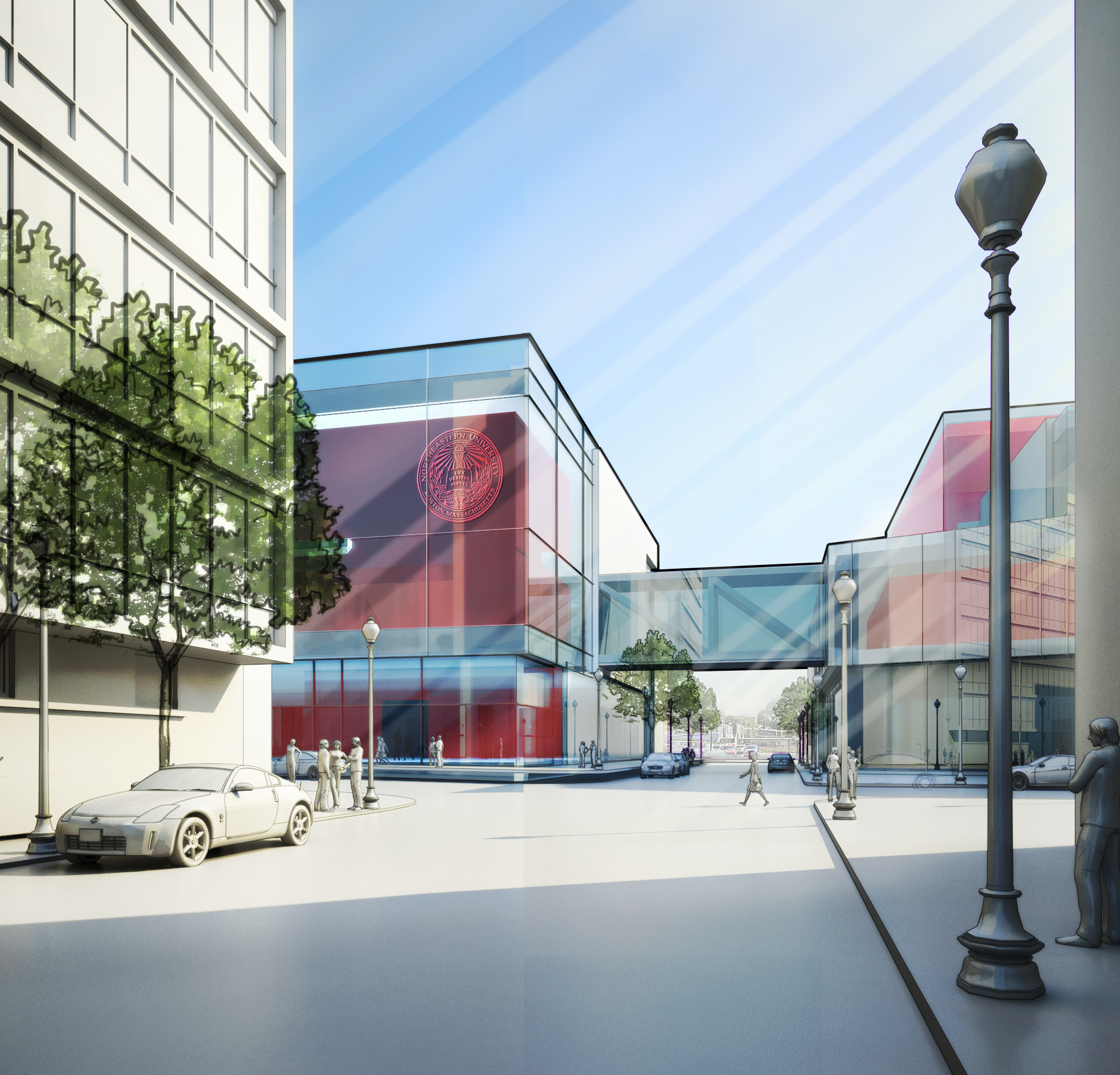
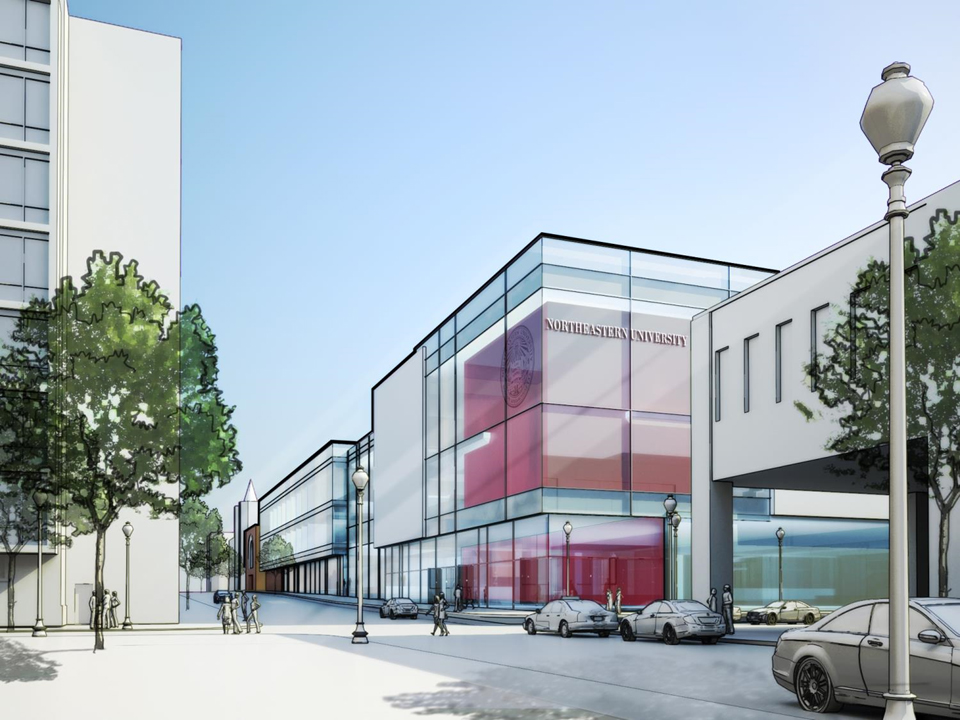
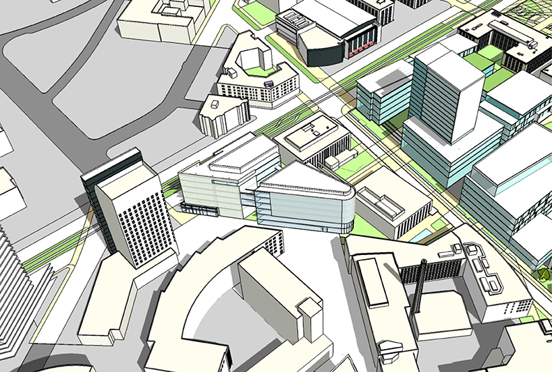
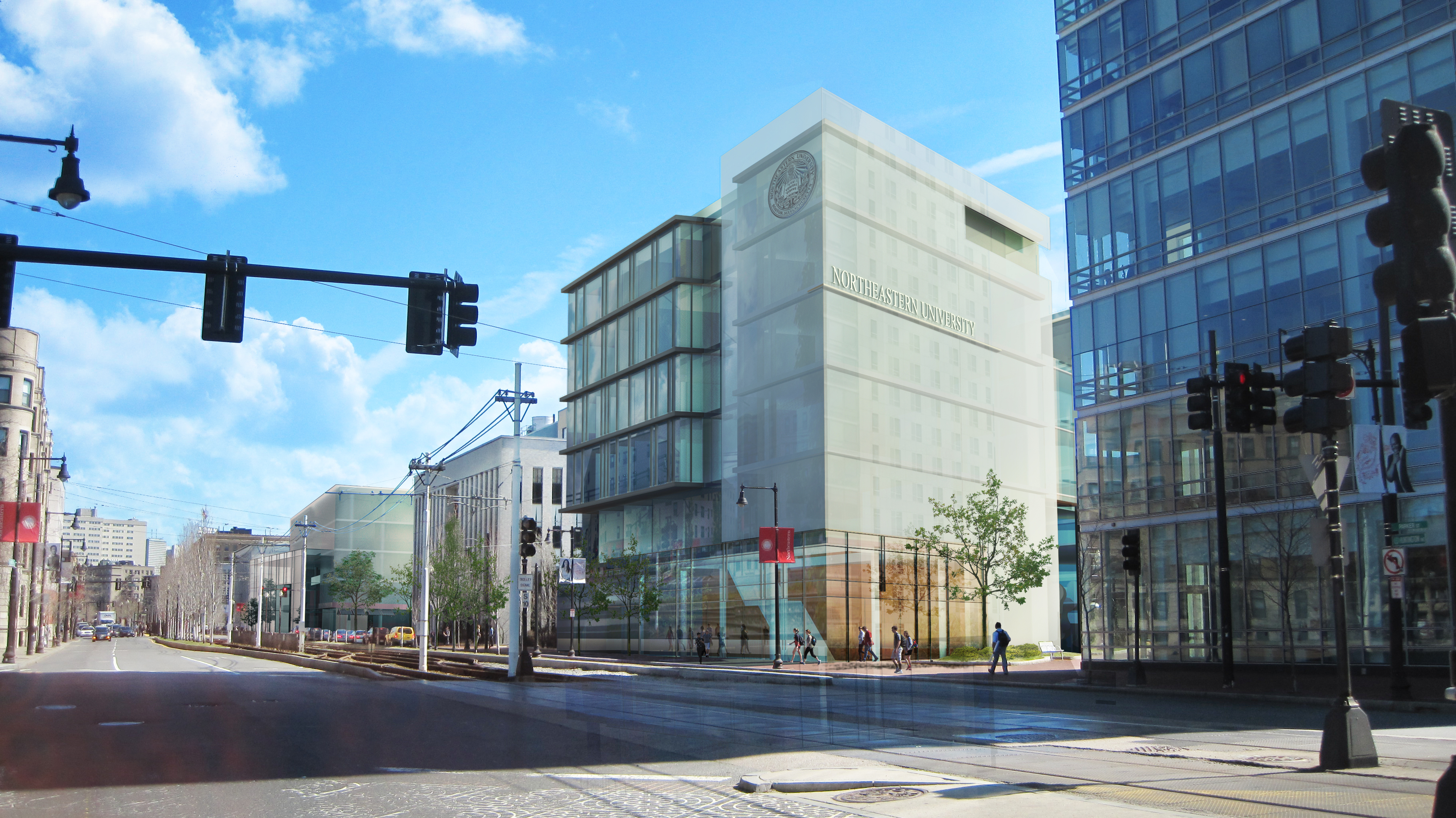
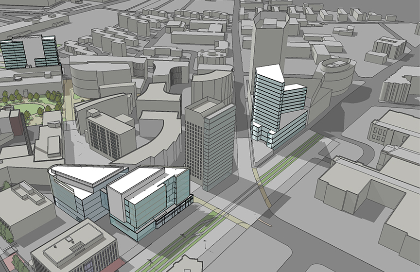
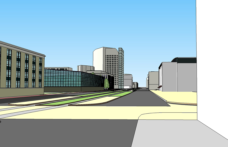
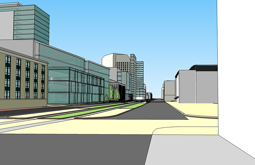
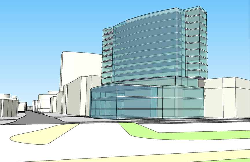
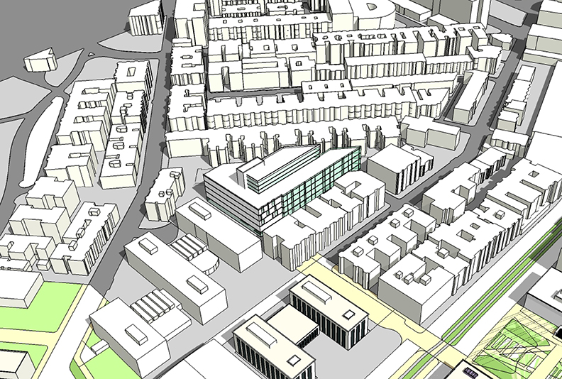
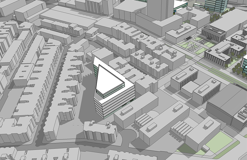
The Cabot Center and Barletta Natatorium, built by Northeastern in 1954, has also served the University’s athletic and recreation needs for over a half century, but is challenged by its age and condition. The building also does not help activate the public realm with its considerable length of blank façade along Huntington. While the age of the Cabot Center contributes to the decision to redevelop the site, the principal driver of its redevelopment is the prominent public nature of the site and the opportunity that a mixed-use facility provides for Huntington Avenue and the public face of the University.

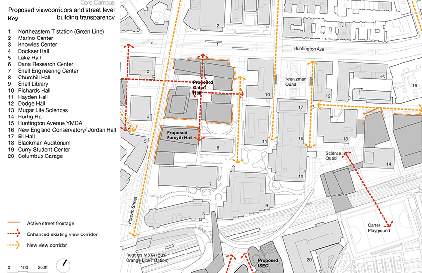
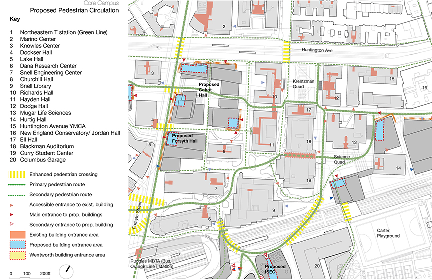
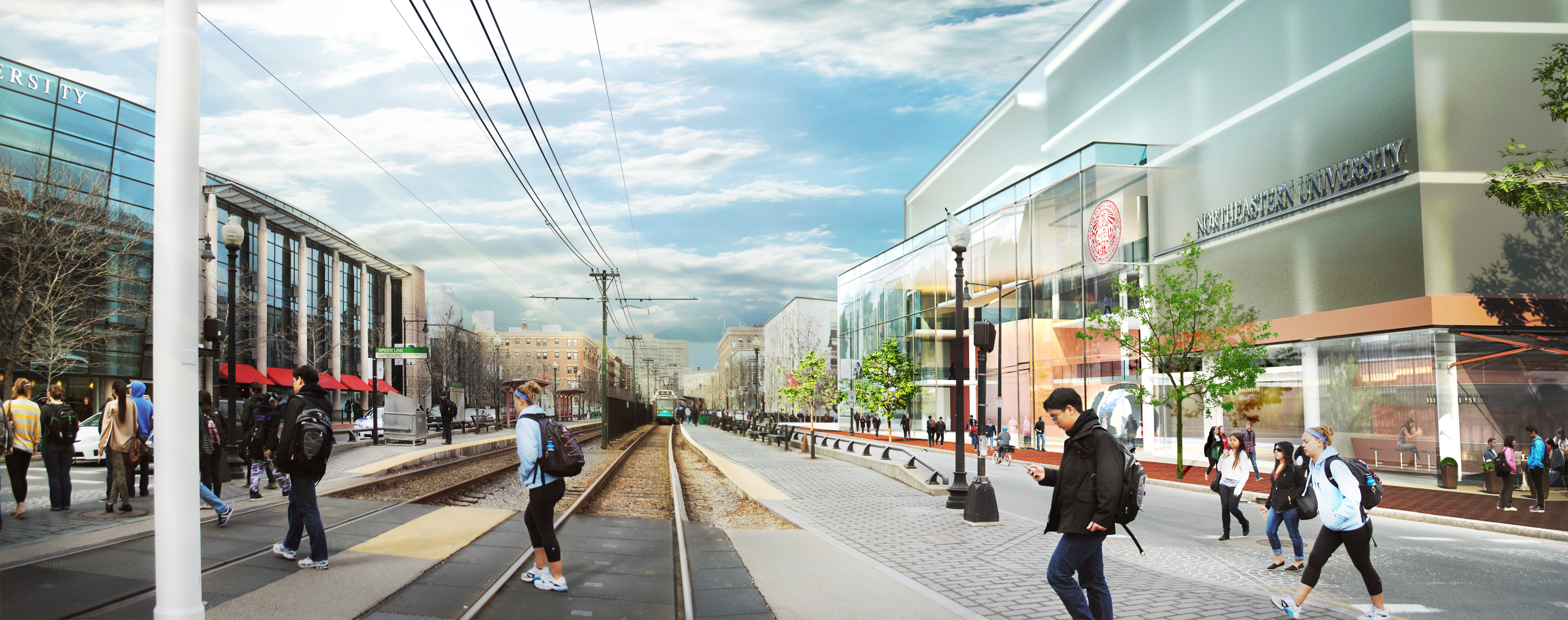
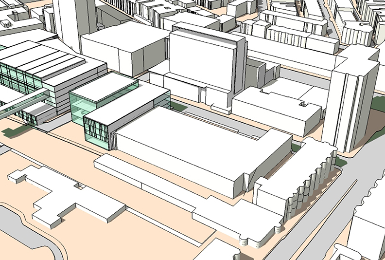
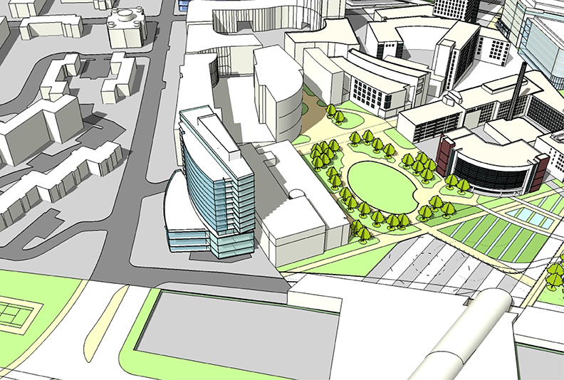
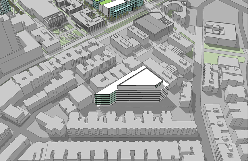
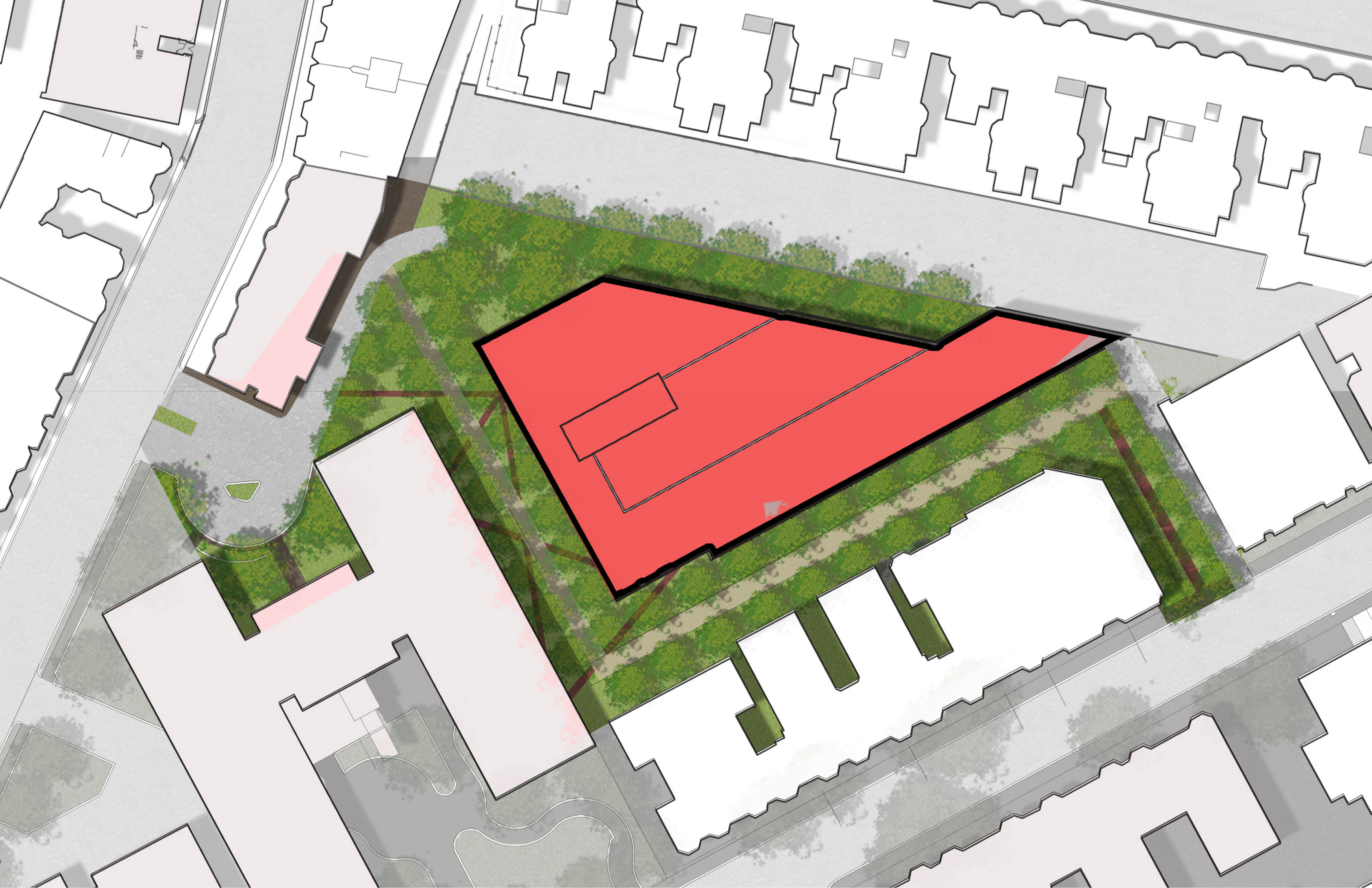
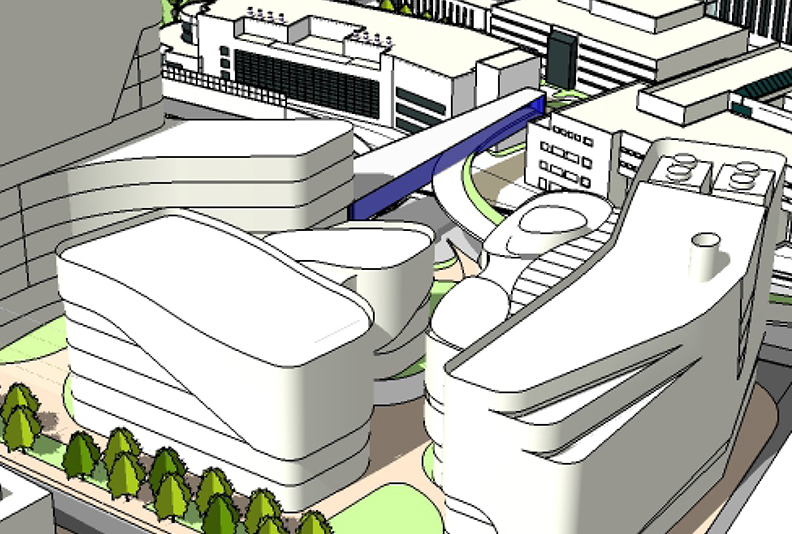
The proposed redevelopment of the Forsyth building for academic and/or housing use will provide much needed space in the core of the campus, adjacent to the College of Engineering facilities. The master plan proposes active, transparent uses along the Forsyth Street frontage and recognizes the redevelopment of the Forsyth Building as a centerpiece to the overall master plan initiative of improving the pedestrian environment and character of an important north-south axis. The adjacent, mixed-use development proposed on the Cabot site also proposes to introduce active, transparent, public uses along the east side of Forsyth Street as well as along the Huntington Avenue frontage. The master plan identifies opportunities for academic space, residential space and cultural uses such as performing and visual arts facilities and venues on the Cabot site, recognizing the goal of Northeastern contributing to the Avenue of the Arts. The plan envisions a series of buildings on that define an internal open space quad/courtyard that will also be accessible and visible from Huntington Avenue and Forsyth Streets – a transformation from the large, single use footprint of the existing Cabot Center.

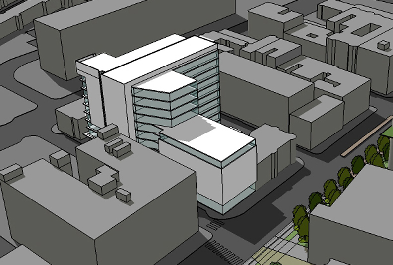
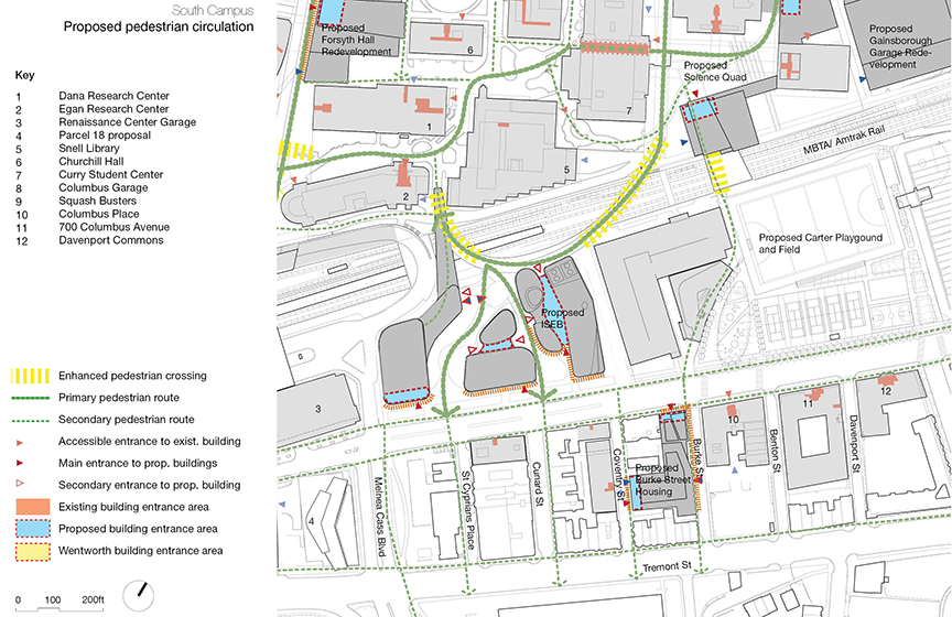
This open space and the proposed pedestrian corridors linking it are seen as an important part of the overall sequence of campus open space and provide an important east-west connection parallel along the northern edge of the campus across Forsyth Street. The transparency and public nature of the Huntington façade, and the connection through to the center of the campus, also provide another important north-south link contributing to the overall porosity of the campus and the increasing emphasis on movements across the tracks toward Columbus Avenue. The redevelopment of the Cullinane site anticipates the opportunity for a new science building, potentially connected to both Mugar and Hurtig – both existing science facilities. A building on this site will enable better utilization and renovations of the existing, older facilities. This proposal anticipates improvements to the existing science quadrangle landscape in order to foster better through-campus connections linking the proposed pedestrian track crossings spanning the MBTA Orange Line, Commuter Rail and Mainline AMTRAK through the Science Quad to St. Botolph Street. The Cullinane redevelopment will also provide opportunities for increased and improved frontages along St. Botolph.

The final component to the Core Campus precinct is the demolition of Robinson Hall to accommodate an additional science building, also potentially linked to Hurtig Hall. The demolition of Robinson (built by NU in 1965) will allow for a new facility in place of one of the smallest and least efficient academic buildings on the campus. While Robinson is a product of the original white glazed brick campus aesthetic, it does not participate in an iconic ensemble as do the original Krentzman Quad buildings and occupies a much less visible sector of the campus abutting the service road. This proposal also anticipates potentially extending over the existing service road enabling a future decked crossing over the MBTA rail corridor to Carter Playground.

Core Campus:

Proposed Site Plan

Core Campus:

Visual Connectivity

Core Campus:

Proposed Pedestrian Circulation

Core Campus:

Proposed Vehicle Circulation

Core Campus:

Conceptual View Looking East Down Huntington Avenue

Core Campus:

Proposed Conceptual View from the North West

Core Campus:

Proposed Conceptual View from the North East

East Campus

+

Gainsborough Garage

  • Location: 10 Gainsborough Street
  • Site Size: 1.47 Acres
  • Existing Uses: Parking / Facilities
  • Proposed Uses: Mixed-Use (Student Life, Parking,Athletics)
  • Proposed Height: 6 to 9 Stories
  • Development Size: 200,00 to 240,000 GSF (including structured parking for approx. 300 vehicles)
+

Matthews Arena

  • Location: 238-262 St.Botolph Street
  • Site Size: 0.7 acres
  • Existing Use: Surface parking lot
  • Proposed Use: Athletic Facilities/Event/ Student Life
  • Proposed number of stories: 3-5
  • Proposed Size: 110,000- 120,000 GSF

East Campus

East Campus Precinct

The East Campus Precinct consists of two proposed projects that will contribute to the re-centering of Northeastern Athletics along the St. Botolph- Gainsborough Street corridors. This shift will create a strong adjacency between varsity athletic facilities and the Matthews Arena while creating an addition to the arena that will provide program space and infrastructure to improve the utilization, performance and functionality of the century old facility. The creation of the Matthews addition and a new athletic facility on the Gainsborough garage site will also provide Northeastern with much needed contemporary athletic facilities. This proposal will also further enable the redevelopment of the prominent Huntington Avenue site of the existing Cabot Center – at the core of the campus and its interface with the community and the city. While the shift of athletics to the east will allow improvements to the core, the master plan proposal for Gainsborough – St. Botolph will also contribute to a transformation of this part of the city which has long seemed unfriendly to pedestrians. The two projects will replace a surface parking lot at Matthews and the Gainsborough structured parking facility, a converter industrial building.

In conjunction with the New England Conservatory of Music project, the Northeastern Master Plan proposes to create active, vibrant and transparent street frontages along St. Botolph and Gainsborough Streets, with an emphasis on the importance of the intersection. Open, public lobbies for both facilities, student activity space including potential café’s or other retail uses are envisioned. Upper floors will also provide opportunities for transparency and vibrancy through potential visual connections to athletic and recreation spaces. With the redevelopment of the Gainsborough Garage for an athletic facility, the master plan recognizes that the site must continue to serve the critical parking and loading functions that it does today given the importance of the location for parking events for Matthews, Jordan Hall and Symphony Hall. The proposal includes replacing all of the existing structured spaces, partially below grade and partially above grade, in a structured garage that is part of the proposed athletic facility abutting the tracks to the south. Access to this parking will continue to occur on Gainsborough as it does today, as would access to the campus service road running parallel to the tracks. Likewise, service access to the Arena must also remain off of Gainsborough Street beneath the proposed Matthews addition. Consequently, while the Gainsborough-St. Botolph intersection will be a transformed public and pedestrian friendly environment, it must also continue to accommodate a significant parking and service access as it does today. Therefore, traffic calming and pedestrian safety design measures, as proposed by the NEC development project, will be incorporated into the public realm improvements associated with the East Campus Precinct.

The master plan also anticipates improvements to the open space within the Arena setback along St. Botolph Street currently occupied by surface parking. These improvements are part of an overall master plan initiative that recognizes the future prominence and increased activity that will occur along the St. Botolph corridor, beginning with the GrandMarc project and the increased student presence it will bring. The master plan also proposes a potential future enclosed pedestrian bridge connecting the Matthews Arena addition and the proposed athletic facility across Gainsborough Street. While this connection will greatly improve the functionality of both athletic facilities and the arena, the bridge, as an elegantly detailed and distinct architectural element, can also serve as an urban design feature for the precinct. With the recognition that Gainsborough Street south of St. Botolph must function as an important pedestrian corridor as well as an active parking and service access street, the bridge can act as a gateway element, creating a “portal” as the street transitions from a pedestrian zone of activity, to more of a service orientation toward the tracks. The bridge is proposed to be set back from the intersection and at an elevation high enough above the street to sufficiently frame the prominent corner and to help contribute to the sense of an “urban room” and the prominence of the intersection.

East Campus:

Proposed Site Plan

East Campus:

Visual Connectivity

East Campus:

Proposed Pedestrian Circulation

East Campus:

Proposed Vehicle Circulation

East Campus:

Proposed conceptual View from the North West

East Campus:

View Looking South down Gainsborough Street

East Campus:

View Looking East down St. Botolph Street

West Campus

+

Burstein Rubenstein

  • Location: 458 / 464 Huntington Ave
  • Site Size: 0.45 Acres
  • Existing Use: Residential
  • Proposed Uses: Residential / Academic / Commercial
  • Proposed Height: 18 stories
  • Development Size: 190,000 to 200,000 GSF
  • Total number of beds: 377 (at 350 SF/bed)
  • Net new beds: 150
+

Cargill Hall

  • Location: 45 Forsyth St. / 420 Huntington Ave. / 55 Forsyth St.
  • Site Size: 0.73 acres
  • Existing Use: Academic
  • Proposed Use: Academic and Residential
  • Proposed Heights: Cargill (north) 12 to 14 stories / Cargill (south) 6 to 8 Stories
  • Development Size: 190,000 to 200,000 GSF (including 51,000 GSF residential use)
  • Total number of beds: 150 (at 350 SF/bed)
+

Ryder Hall

  • Location: 66 Leon St (Ryder Lot)
  • Existing Use: Surface Parking Lot
  • Proposed Uses: Academic / Residential
  • Proposed Height: 8 to12 Stories
  • Development Size: 150,000 to 200,000 GSF

West Campus

The West Campus consists of three distinct, yet important proposals, all of which occupy prominent frontages on the campus public edges. Each one is also indicative of the scarcity of developable land on the Northeastern campus and proposes the kind of surgical, infill developments required to meet the University’s needs.

The redevelopment of Burstein and Rubenstein proposes to replace 1920’s housing stock with a high-rise residential tower sitting above an academic podium base – a similar model to the West Village H tower at the intersection on the opposite side of Parker Street. The project offers an opportunity to continue the creation of a more transparent, active street frontage along Huntington Avenue and also anticipates complimenting the proposed research campus planned by Wentworth on Sweeney Field. The location of housing density on this site is a logical continuation of the growth of the West Village over the past decade and the precedent of student residential towers along Huntington Avenue in both directions. The massing of the site proposes to create a slender tower footprint, pulled back from Huntington with a street level podium consistent with the institutional scale and height elsewhere along the corridor. The project is also sited in such a way as to potentially share loading access and service with the Wentworth Sweeney Field proposal.

The other prominent Huntington Avenue site in the West Campus is enabled by the assembly of three small, inefficient and undistinguished campus buildings: Cargill Hall, Stearns Hall and Kariotis, built between 1976 and 1982. These buildings are arranged around an inaccessible, elevated plaza that is unpleasant and rarely used. By combining these three sites, and linking the development below grade to the existing law school buildings, Dockser and Knowles, a more useful and prominent academic development opportunity is achieved. This project also enables an at-grade pedestrian connection, replacing the elevated plaza and allowing internal campus connections between the core campus and West Village as well as campus access from Huntington Avenue. The Cargill-Stearns redevelopment presents an opportunity for Huntington Avenue frontage for cultural, retail and/or other public uses. This project will advance the overall master plan principal of creating a more vibrant, transparent public face to the Northeastern campus.

The West Campus also envisions the opportunity to complete the West Village by proposing a residential tower on the Ryder Hall surface lot just north of where Ruggles Street crosses the Orange Line. The proposed footprint respects the setback easement for the future Urban Ring transit line and aligns with the Ruggles setback of the existing West Village housing. This residential tower has the potential to create an elegant and complimentary vertical element to West Village H across the West Campus, and International Village across the Southwest Corridor Park.

Impacts to the functionality and indoor quality of Ryder Hall need to be carefully measured, and development of the Ryder lot will likely trigger full renovation of the existing academic building or, potentially, complete redevelopment. While not a prominent commercial location, the ground floor uses of the Ryder Lot development do offer the potential for public uses and active transparency at the ground level. The prominence of this location is reinforced by the crossing of the South West Corridor Park to the south as it reengages with the decked park to the west.

West Campus:

Proposed Site Plan

West Campus:

Visual Connectivity

West Campus:

Proposed Pedestrian Circulation

West Campus:

Proposed Vehicle Circulation

West Campus:

Proposed conceptual View from the North West

West Campus:

Proposed Conceptual View from the South

West Campus:

Proposed Conceptual View from the North East

West Campus:

Existing Perspective along Huntington Avenue Looking West

West Campus:

Proposed Perspective along Huntington Avenue Looking West

West Campus:

Existing Perspective along Ruggles Street Looking North

West Campus:

Proposed Perspective along Ruggles Street Looking North

West Campus:

Birdseye View of Ryder Lot Building Looking North

North Campus

+

North Lot

  • Location: North Lot
  • Site size: 1.95 acres
  • Existing use: Surface parking lot
  • Proposed use: Academic
  • Proposed number of stories: 6
  • Proposed Size: 150,000-220,000 GSF

North Campus

North Campus Precinct

The North Campus Precinct consists of a single proposed project on the existing North surface parking lot. The master plan anticipates a general purpose academic and classroom building that will serve as swing space to enable renovation and redevelopment of existing academic buildings such as Forsyth, Ryder, and the United Realty complex. Given the fact that the parcel is embedded within a mid-block condition and does not have direct street frontage, the urban design principles governing the plan are to mitigate the impacts on the abutting residential properties through massing, setbacks and landscape buffers.

Access to the North Lot is challenging but the master plan proposes to utilize the 2 existing vehicular and pedestrian access points from the south on St. Stephen Street, and from the west through the drop off in front of the Stetson East residence hall accessed from Hemenway Street. Both of these access drives can offer vehicular entry and exit from the site, as they currently do for the surface parking lot. Loading would occur off of the Hemenway Street access drive, adjacent to Stetson Hall and service vehicles would not circulate through the site behind the St. Stephen Street residential buildings. Further utilization and connections are also possible through a potential physical link to the existing Stetson Hall, although the new North Lot development would not contain residential or student life uses. The edges of the north lot site that abut residential properties on St. Stephen and Gainsborough streets will both be treated as a landscaped buffer between the North Lot building and the rear yards of the properties. A grade change between the proposed building and the Gainsborough Street properties will remain. The facades of the building will be designed to be respectful of the interior lot condition so as to minimize impacts on residential properties. The uses proposed for the building are intentionally low impact relative to student activities as well as vehicular and foot traffic. Student centered uses such as dining, residential uses, student center space, outdoor recreation space and performance venues are not proposed for this site. Foot traffic will be limited to the two access points from St. Stephen and Hemenway streets.

The massing of the proposed North Lot development is intended to be respectful of the scale of the abutting properties and proposes upper story setbacks along the rear of the St. Stephen’s street properties. The existing setback and grade change along the Gainsborough Street properties creates an adequate buffer zone along the northeast façade. However the proposed massing also includes an upper story setback behind the abutting Hemenway Street properties owned by Northeastern. The building’s façade design will employ scaling devices that respect the abutting properties and will limit the use of large expanses of glazing so as to minimize impacts at night. The more public nature of the building entrances will relate to the two access points from St. Stephen Street and Hemenway so that the building does present some modest visibility from the street, however the overall design is intended to be otherwise understated and respectful of the residential context. Other public realm improvements within the North Campus Precinct include a proposed narrowing of Forsyth Street north of Huntington by eliminating a lane of on-street parking adjacent to the side of the Marino Center. The associated streetscape improvements along this block will be an important extension of the proposed Forsyth Street improvements south of Huntington to Ruggles Station. The continuation of the Forsyth pedestrian improvements north of Huntington become an important link to the existing pedestrian path adjacent to the 140 The Fenway building, connecting the Northeastern campus to the Emerald Necklace. At a broader neighborhood scale, this connection is seen as an important piece of the master plan goal of linking the Fenway and the Southwest Corridor Park south of the tracks.

North Campus:

Proposed Site Plan

North Campus:

Visual Connectivity

North Campus:

Proposed Pedestrian Circulation

North Campus:

Proposed Vehicle Circulation

North Campus:

Proposed conceptual View from the North West

North Campus:

Proposed Conceptual View from the North East

North Campus:

Conceptual View Looking East Down Huntington Avenue

South Campus

+

Columbus Lot

  • Location: 795 Columbus Avenue
  • Site Size: 2.7 Acres
  • Existing Use: Surface Parking Lot
  • Proposed Uses: Interdisciplinary Sciences and Engineering, Academic, Student Life, ISEC, Commercial, Parking
+

Burke Street Housing

  • Location: 10 Burke Street
  • Site Size: 0.5 Acres
  • Existing Uses: Parking
  • Proposed Uses: Mixed Use/ Office and Residential
  • Development Size: 175,000- 200,000 GSF
  • Number of Beds: 350-600

South Campus

Planning and Urban Design Goals

The Master Plan proposes completing the ongoing transformation and revitalization of Columbus Avenue in the South Campus Precinct that began during the prior IMP.

The gradual infill housing strategies along the south side of the street will continue with the proposed mixed use residential infill project on the Burke Street lot.

On the north side of Columbus, Northeastern’s proposed renovation and expansion of the Carter Playground will have a significant and positive influence on the Columbus Avenue corridor and the South Campus precinct.

Future improvements also include a potential new and/or improved MBTA crossing at Camden Street and the west end of the Mass. Ave. station platform.

The master plan redevelopment of the Columbus parking lot represents a significant opportunity to complete the Columbus Avenue face of the campus and to shift the future balance of campus activity and presence to the Roxbury side of the southwest corridor. The master plan proposes a blend of active and transparent building frontages along Columbus Avenue as well as open spaces that gesture toward the public street, not unlike the Krentzman Quad does to Huntington Avenue.

South Campus:

Proposed Site Plan

South Campus:

Visual connectivity

South Campus:

Proposed Pedestrian Circulation

South Campus:

Proposed Vehicle Circulation

South Campus:

Proposed View from the North

South Campus:

Proposed View from the South

South Campus:

Proposed Site Plan

South Campus:

Burke Street Student Housing